Varduva
| Varduva | |
|---|---|
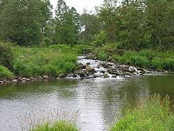 Varduva near Griežė, Mažeikiai District Municipality | |
| Country | Lithuania |
| Physical characteristics | |
| Main source |
Near Paparčiai village, Skuodas District Municipality 56°9′29″N 21°55′4″E / 56.15806°N 21.91778°E |
| River mouth |
Venta 56°25′26.75″N 22°12′29.76″E / 56.4240972°N 22.2082667°ECoordinates: 56°25′26.75″N 22°12′29.76″E / 56.4240972°N 22.2082667°E |
| Length | 90.3 km (56.1 mi) |
| Basin features | |
| Basin size | 586.7 km2 (226.5 sq mi) |
Varduva is a river in northwestern Lithuania. Its length is 90.3 kilometres (56.1 mi).[1] It is a left tributary of Venta; their confluence is on the Lithuania–Latvia border. Its origins and upper reaches are located within the Žemaitija National Park. Its largest tributary is Sruoja. Larger settlements situated near Varduva include Žemaičių Kalvarija, Seda, Renavas, Ukrinai. Varduva has five small hydroelectric power plants: Kulšėnai, Ukrinai, Vadagiai, Juodeikiai, Renavas. The largest of these plants in Juodeikiai produced 2.99 GWh of electricity in 2010.[2]
References
- ↑ "Ventos upių baseinų rajono paviršinių vandens telkinių apsaugos problemų apžvalga" (PDF). Environmental Protection Agency of Lithuania. 2013. p. 2. Retrieved 2015-10-04.
- ↑ "Hydropower in Lithuania" (PDF). Lithuanian Hydropower Association. 2011. pp. 54–61. Retrieved 2015-10-04.
| Wikimedia Commons has media related to Varduva. |
This article is issued from
Wikipedia.
The text is licensed under Creative Commons - Attribution - Sharealike.
Additional terms may apply for the media files.