Unterelbe
| Unterelbe | |
|---|---|
 Unterelbe, from Geesthacht to Cuxhaven | |
| Country | Germany |
| States | Hamburg |
| Basin features | |
| River system | Elbe |


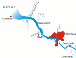
The Unterelbe (lit. Underelbe) or, in English often the Lower Elbe, names to the lower reaches of the river Elbe in Germany swayed by the tides. It starts at kilometre 586, at the floodgate of Geesthacht, where the Elbe forms the border between Lower Saxony and Schleswig-Holstein. . It onflows downstream, then landmarking the border between Lower Saxony and Hamburg, before fully throughfaring into Hamburg homelands. In Hamburg the Unterelbe offbrooks two anabranches, Norderelbe and Süderelbe, the latter now slightly a cut-off wend. Where Norderelbe and Süderelbe once in-met again, at kilometre 634 there is a bight called the Mühlenberger Loch. This marks the beginning of the stretch of the Unterelbe which called the Niederelbe. After leaving Hamburg it shapes the border between Lower Saxony and Schleswig-Holstein, again. The end it marks out by the Kugelbake in Cuxhaven at kilometre 727.73. It onflows further into the Wadden Sea as the Außenelbe, where it runs hard by the Hamburg islands Scharhörn and Nigehörn.
See also
Coordinates: 53°36′N 9°35′E / 53.600°N 9.583°E