Umiujaq
| Umiujaq ᐅᒥᐅᔭᖅ | |
|---|---|
| Northern village municipality | |
 | |
 Umiujaq | |
| Coordinates: 56°32′N 76°33′W / 56.533°N 76.550°WCoordinates: 56°32′N 76°33′W / 56.533°N 76.550°W[1] | |
| Country | Canada |
| Province | Quebec |
| Region | Nord-du-Québec |
| TE | Kativik |
| Constituted | December 20, 1986 |
| Government[2] | |
| • Mayor | Jobie Crow |
| • Federal riding | Abitibi—Baie-James—Nunavik—Eeyou |
| • Prov. riding | Ungava |
| Area[2][3] | |
| • Total | 28.59 km2 (11.04 sq mi) |
| • Land | 28.59 km2 (11.04 sq mi) |
| There is an apparent contradiction between two authoritative sources | |
| Population (2016)[3] | |
| • Total | 442 |
| • Density | 15.5/km2 (40/sq mi) |
| • Change (2011–16) |
|
| • Dwellings | 103 |
| Time zone | UTC−5 (EST) |
| • Summer (DST) | UTC−4 (EDT) |
| Postal code(s) | J0M 1Y0 |
| Area code(s) | 819 |
| Website |
www |
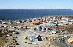
Umiujaq (Inuktitut: ᐅᒥᐅᔭᖅ) is a northern village (Inuit community) near the eastern shore of Hudson Bay in Nunavik in northern Quebec, Canada. The village was established in 1986 by Inuit from Kuujjuarapik, 160 km to the south, who decided to relocate away from the area affected by the James Bay Hydro-electric Project. The population in the Canada 2016 Census was 442. Umiujaq is the closest community to Tursujuq National Park, which was officially opened on July 18, 2013, and covers 26,106.7 km2 (10,079.9 sq mi).[4]
Umiujaq, meaning "which resembles a boat" in the Inuttitut language, is located at the foot of a hill resembling an overturned umiaq, a traditional Inuit walrus-skin boat. The village is located 15 km (9.3 mi) west of Richmond Gulf (French: Lac Guillaume-Delisle; Inuttitut: Tasiujaq (which resembles a lake)), an immense inland bay which is joined with Hudson Bay by a rocky gulch.
Inaccessible by road, Umiujaq is served by the small Umiujaq Airport.
As other villages in the Kativik region, the police services in Umiujaq are provided by the Kativik Regional Police Force[5].
History
The Inuit negotiated a clause into the 1975 James Bay and Northern Quebec Agreement that provided for the relocation of the Inuit from Kuujjuarapik to a new settlement unaffected by hydro-electric development. Following a referendum, in 1982 the Inuit opted to create a new community where they could preserve their traditional lifestyle in an area where fish and game were not threatened by hydro-electric development. After extensive studies a location was selected, and construction of the new village was completed in 1986.
Education
The Kativik School Board operates the Kiluutaq School.[6]
References
- ↑ Reference number 178760 of the Commission de toponymie du Québec (in French)
- 1 2 Geographic code 99080 in the official Répertoire des municipalités (in French)
- 1 2 "(Code 2499080) Census Profile". 2011 census. Statistics Canada. 2012.
- ↑ Parc national Tursujuq
- ↑ KRPF. "General Information". Home. Retrieved 2017-07-03.
- ↑ "Our Schools." Kativik School Board. Retrieved on September 23, 2017.