Umm el Kanatir
Umm el-Kanatir or, in scientific literature, Umm el-Qanatir (Arabic: ام القناطر Umm al-Qanāṭir, lit. "Mother of the Arches") is an archaeological site on the Golan Heights, whose main phase is dated to the mid-5th - 8th centuries.[1][2] Excavations have revealed a Roman-era settlement, first inhabited by pagans and later by Jews, who left behind the ruins of an exquisite synagogue when they abandoned the town after it being destroyed by the catastrophic 749 earthquake.[1] The site is located 10 kilometers east of the Dead Sea Transform,[3] two kilometers west of Kibbutz Natur.[1]
Identification attempts based on Jewish sources have led to two possible ancient names: Kantur, mentioned by Rabbi Menachem di Luzano in his book Ma'arikh (16th/early 17th century);[4] and possibly Qamtra, the name of a place mentioned in the Talmud and with a Jewish past dating back to the Byzantine period.[2][5]
Etymology

The name of the site derives from its location 200 meters from a natural spring that flows from the cliff into three basins that were once topped by monumental basalt arches, one of which has survived.[1]
Some Israeli authorities are starting to use the new Hebrew name of Ein Keshatot ('Spring of the Arches'), such as seen on official postage stamps.[6] The site is also being advertised as Rehavam's Arches, so named after former Israeli Minister of Tourism, Rehavam Ze'evi.[7]
History

The site is believed to have been a pagan Roman town that venerated the nearby spring. Jews began to settle in the vicinity in 23 BCE.[8] Early Jewish inhabitants of Umm el-Kanatir established a flax industry there, using the water for washing and whitening flax from which they wove fine cloth. The textiles were sold to wealthy residents in the nearby towns of Sussita and Beit Saida.[1] The villagers may have engaged in mixed farming, and raised sheep and olives, although no terracing has been found.[1]
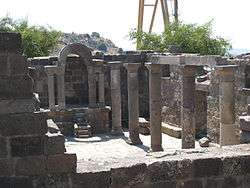
It was apparently in the fifth century that the Jewish residents built a large synagogue, which they embellished during the sixth century.[1] The building was 18 meters (59 feet) long by 13 meters (43 feet) wide and calculated to have been 12 meters (39 feet) high, making it one of the largest of at least 25 ancient synagogues discovered in the region. It was destroyed in the Golan earthquake of 749, when the Jewish inhabitants left the shattered settlement.[1]
Local Syrian shepherds continued to inhabit the ruins of Umm el-Kanatir into the 1950s, reusing the carved stones.[1]
The existence of a synagogue at the site was first documented in 1884, by Laurence Oliphant and Gottlieb Schumacher.[9] Amid ruined walls and large blocks of stone, Oliphant discovered a stone carving of an eagle, a fragment of a cornice, a large triangular slab that he believes was placed on the lintel of the main entrance and fragments of Corinthian capitals.[9] The eagle, a well-known motif in ancient Jewish art, particularly in the Golan and Galilee, is visible on a double column and on the front gable of the synagogue and might come from the same workshop as the decorated Torah shrine base from 'En Samsam, another Golan Heights site.[10][11][12]
The catastrophic 749 earthquake brought the settlement to an end.[2]
Reconstruction
Reconstruction of the synagogue is under way, supervised by Yehoshua Dray and Haim Ben-David of Kinneret Academic College and Bar-Ilan University.[1] The project, inaugurated in 2003, uses special high-tech computer technology to code and digitally record the stones. Blocks are then labelled with RFID chips and a special crane lifts and inserts them in the correct sequence.[13] With the help of this technology, archaeologists believe the synagogue is being restored with great accuracy.[14]
See also
| Wikimedia Commons has media related to Um el Kantar. |
References
- 1 2 3 4 5 6 7 8 9 10 S. G. Rosenberg (February 19, 2009). "The synagogue of Umm el-Kanatir". Jerusalem Post.
- 1 2 3 ,Stephen Rubin, Discovering Jewish History on the Golan Heights, on the website of The Tower and The Tower Magazine
- ↑ Estimating location and size of historical earthquake by combining archaeology and geology in Umm el-Qanatir, Dead Sea Transform
- ↑ Eli Yassif, Intertextuality in folklore: pagan themes in Jewish folktales from the Early Modern Era, for the correct spelling and century
- ↑ Urman, Dan and Flesher, Paul Virgil McCracken Ancient Synagogues: Historical Analysis and Archaeological Discovery, p. 549, Brill, 1998, 2nd edition, series: Studia Post Biblica, No 47 (Themes in Biblical Narrative) (v. 1 & 2), ISBN 9789004112544. Accessed 5 September 2018.
- ↑ Israel Post, Israel's National Heritage – Landmarks: Ein Keshatot, Golan, February 11, 2014, via virtualstampclub.com. Accessed 5 September 2018.
- ↑ To Rehavam's Arches, on the Israel Ministry of Tourism website. Accessed 5 September 2018.
- ↑ Syrian-Israeli peace in the Golan: No walk in the park
- 1 2 Studia Post Biblica, Ancient Synagogues: Historical Analysis and Archaeological Discovery, Dan Urman and Paul V.M. Flesher
- ↑ Rachel Ḥachlili, Ancient Jewish Art and Archaeology in the Land of Israel: Motifs of Jewish Art, p. 333, accessed 5 September 2018
- ↑ Rachel Hachlili, Ancient Synagogues - Archaeology and Art: New Discoveries and Current Research, p. 147, Brill, 2013, series: Handbook of Oriental Studies: Section 1; The Near and Middle East (Book 105), ISBN 978-9004257733, accessed 5 September 2018
- ↑ Torah shrine base, En Samsam, Golan Heights, accessed 5 September 2018
- ↑ For the Love of the Land: The Golan Heights
- ↑ Technology bringing history back to life