Tunnel of Eupalinos
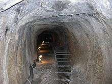
 Inside the Eupalinian aqueduct, Samos, in one of its most spacious parts. | |
| Overview | |
|---|---|
| Location | Samos Island, Greece |
| Coordinates | 37°41′38″N 26°55′48″E / 37.694°N 26.930°ECoordinates: 37°41′38″N 26°55′48″E / 37.694°N 26.930°E |
| Status | Open |
| Operation | |
| Opened | ca. 6th century BC |
| Technical | |
| Length | 1036m |
The Tunnel of Eupalinos or Eupalinian aqueduct (in Greek: Efpalinion orygma - Ευπαλίνιον όρυγμα) is a tunnel of 1,036 m (3,399 ft) length in Samos, Greece, built in the 6th century BC to serve as an aqueduct.[1] The tunnel is the second known tunnel in history which was excavated from both ends (Ancient Greek: αμφίστομον, translit. amphistomon, "having two openings"), and the first with a geometry-based approach in doing so.[2] Today it is a popular tourist attraction.
Historical data
In the sixth century BC, Samos was ruled by the famous tyrant Polycrates.[1] During his reign or according to the local guides before his reign, two groups working under the direction of the engineer Eupalinos from Megara dug a tunnel through Mount Kastro to build an aqueduct to supply the ancient capital of Samos (today called Pythagoreion) with fresh water. This was of the utmost defensive importance; because the aqueduct ran underground, it could not easily be found by an enemy, who might otherwise cut off the water supply. The Eupalinian aqueduct was used for hundreds of years as an aqueduct then later as a defensive shelter, as proved from archaeological findings. It was rediscovered in 1882-1884 and today is open to visitors.
Text of Herodotus
The Eupalinian aqueduct is described by Herodotus (Histories 3.60), without whom it might not have been discovered:
- I have dwelt longer upon the history of the Samians than I should otherwise have done, because they are responsible for three of the greatest building and engineering feats in the Greek world: the first is a tunnel nearly a mile long, eight feet wide and eight feet high, driven clean through the base of a hill nine hundred feet in height. The whole length of it carries a second cutting thirty feet deep and three broad, along which water from an abundant source is led through pipes into the town. This was the work of a Megarian named Eupalinus, son of Naustrophus.[3]
Description
The tunnel took water from an inland spring, which was roofed over and thus concealed from enemies. A buried channel, with periodic inspection shafts, winds along the hillside to the northern tunnel mouth. A similar hidden channel, buried just below the surface of the ground, leads from the southern exit eastwards to the town of Pythagoreion.
In the mountain itself, the water used to flow in pipes in a separate channel several metres below the human access channel, connected to it by shafts or by a trench.
The southern half of the tunnel was dug to larger dimensions than the northern half, which in places is just wide enough for one person to squeeze through and has a pointed roof of stone slabs to prevent rockfalls. The southern half, by contrast, benefits from being dug through a more stable rock stratum.
Surveying techniques of the tunnel
The north and south halves of the tunnel meet in the middle of the mountain at a dog-leg, a technique to assure they did not miss each other. (This method is documented by Hermann J. Kienast and other researchers.) In planning the dig, Eupalinos used now well-known principles of geometry, codified by Euclid several centuries later. With a length of 1,036 metres (3,399 ft), the Eupalinian subterranean aqueduct is famous today as one of the masterpieces of ancient engineering. Eupalinos was aware that errors in measurement and staking could make him miss the meeting point of the two teams, either horizontally or vertically. He therefore employed the following techniques.
In the horizontal plane
The tunnel has a width of approximately 1.8 by 1.8 metres (5.9 by 5.9 ft). Eupalinos calculated the expected position of the meeting point in the mountain. Knowing that two parallel lines never meet, Eupalinos recognized that an error of more than two metres (6.6 ft) horizontally meant that the north and south tunnels would never meet. Therefore, he changed the direction of both tunnels, as shown in the picture (one to the left and the other to the right), so that a crossing point would be guaranteed, even if the tunnels were previously parallel and far away.
![]()
In the vertical plane
Similarly, there was also a possibility of vertical deviations and, again, Eupalinos could not take a chance. He increased the possibility of the two tunnels meeting each other, by increasing the height of both tunnels. In the north tunnel he kept the floor horizontal and increased the height of the roof, while in the south tunnel he kept the roof horizontal and increased the height by changing the level of the floor. His precautions as to vertical deviation proved unnecessary, however, since measurements show that there was very little error; Kienast reports a vertical difference in the opening of the tunnels of only four centimetres (1.6 in).
![]()
Recent findings
Recent research has shown that Eupalinos actually used three straight lines for his navigation. First he constructed a “mountain” line, over the mountain at the easiest part of the summit which gave a non-optimal position both for feeding water into the tunnel and for water delivery to the city. He connected a “south line” to the mountain line at the south side going straight into the mountain around which Eupalinos undulated the south tunnel. At the north side a “north line” is connected to the mountain line. This line guided the cut into the mountain from the north side. After 273 meters Eupalinos directed the tunnel to the west, obviously because of a combination of water, weak rock and mud. When leaving the north line Eupalinos used for navigating an equal-legged triangle with angles 22.5, 45 and 22.5 degrees in theory. Measuring errors occurred and were handled by Eupalinos within the accuracy he could obtain. The cutting of the south tunnel was stopped after 390 metres for the north tunnel to catch up. For the rendezvous of the two tunnels a tentacle was applied at the head of the south tunnel, giving 17 metres wider catching width. When the two tunnels reach within earshot, which can be estimated for this type of rock to approximate 12 metres, the tunnels are directed towards each other and meet at a nearly right angle. This took place almost under the summit, but that was coincidental. Eupalinos levelled around the mountain probably following a contour line but not necessary at the same level as the tunnel. He underestimated his measuring accuracy because, before the rendezvous, he raised the ceiling of the north tunnel by 2.5 m and lowered the floor of the south tunnel by 0.6 m, giving him a catching height of almost 5 metres. At the rendezvous, the closing error in altitude for the two tunnels was a few decimetres. Eupalinos used a unit of 20.59 metres for distance measurements and 7.5 degrees (1/12 of a right angle) for setting out directions.[4]
References
- 1 2 Andreas Nikolaos Angelakis; Larry W. Mays; Demetris Koutsoyiannis (2012). Evolution of Water Supply Through the Millennia. IWA Publishing. pp. 85–87, 264, 355, 407. ISBN 9781843395409.
- ↑ The oldest known tunnel at which two teams advanced simultaneously is the Siloam tunnel in Jerusalem, completed around 700 BC. It has been posited that it was dug by maintaining depths close enough to the surface of the solid karst that the diggers could hear loud banging from the surface guiding the two teams towards one another. Frumkin, Amos; Shimron, Aryeh (2006). "Tunnel engineering in the Iron Age: Geoarchaeology of the Siloam Tunnel, Jerusalem". Journal of Archaeological Science. 33 (2): 227–237. doi:10.1016/j.jas.2005.07.018.
- ↑ Herodotus (1954). The Histories. Translated by Aubrey de Sélincourt. Harmondsworth: Penguin. pp. 199–200.
- ↑ Olson, Åke (2012). "How Eupalinos navigated his way through the mountain-An empirical approach to the geometry of Eupalinos". Anatolia Antiqua, Institut Français d’Études Anatoliennes. XX: 25–34.
Literature
- Olson, Åke (2012). "How Eupalinos navigated his way through the mountain-An empirical approach to the geometry of Eupalinos". Anatolia Antiqua, Institut Français d’Études Anatoliennes. XX: 25–34.
- Burns, Alfred (1971). "The Tunnel of Eupalinus and the Tunnel Problem of Hero of Alexandria". Isis. 62 (2): 172–185. doi:10.1086/350729. JSTOR 229240.
- Van der Waerden, B. L. (1968). "Eupalinos and His Tunnel". Isis. 59 (1): 82–83. doi:10.1086/350338. JSTOR 227855.
- Evans, Harry B. (1999). "Review of Hermann Kienast, Die Wasserleitung des Eupalinos auf Samos". American Journal of Archaeology. 103 (1): 149–150.
- Kienast, Hermann J. (1995). Die Wasserleitung des Eupalinos auf Samos (Samos XIX.). Bonn: Rudolph Habelt. ISBN 3-7749-2713-8. Archived from the original on 2012-02-05. Retrieved 2013-11-17.
- Goodfield, June; Toulmin, Stephen (1965). "How Was the Tunnel of Eupalinus Aligned?". Isis. 56 (1): 46–55. doi:10.1086/349924. JSTOR 228457.
- Apostol, Tom M. (2004). "The Tunnel of Samos" (PDF). Engineering and Science. 1: 30–40.
- The Aqueduct of Eupalinos on Samos, Hermann J Kienast, Ministry of Culture Archaeological Receipts Fund, Athens, 2005. ISBN 960-214-424-6, 60 pp, €9-80
External links
| Wikimedia Commons has media related to Tunnel of Efpalinos. |
- Olson, Åke: (2012). "How Eupalinos navigated his way through the mountain-An empirical approach to the geometry of Eupalinos"
- Dan Hughes: The Tunnel of Eupalinos
- Michael Lahanas: The Eupalinos Tunnel of Samos
- Tunnel of Eupalinos - Hellenic Ministry of Culture and Tourism
- Tom M. Apostol: The Tunnel of Samos