Tukey's Bridge
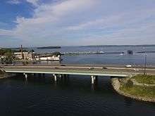
Tukey's Bridge from the west, above Back Bay
| Tukey's Bridge | |
|---|---|
| Coordinates | 43°40′35″N 70°15′23″W / 43.6763°N 70.2565°WCoordinates: 43°40′35″N 70°15′23″W / 43.6763°N 70.2565°W |
| Carries |
eight auto lanes; |
| Crosses | Back Cove |
| Locale | Portland, Maine |
| History | |
| Opened | 1960 |
Tukey's Bridge is a bridge connecting the neighborhoods of Munjoy Hill and East Deering in Portland, Maine. It is part of Interstate 295 and Route 1.
History
Several bridges by the same name have existed connecting the areas.[1][2] The current bridge was completed in 1960 and named for Lemuel Tukey, a tavern owner and tax collector from the Back Cove area of Portland in the late 18th century.[3]
References
- ↑ History of Trains in Portland Archived 2011-06-11 at the Wayback Machine. University of Southern Maine
- ↑ Back Cove Bridge : Tukey's Bridge Archived 2012-07-13 at Archive.is
- ↑ I 295 Interstate-guide.com
- "Tukey Bridge". Geographic Names Information System. United States Geological Survey. 30 September 1980. Retrieved 2010-11-03.
The City of Portland, Maine | |
|---|---|
| General | |
| Geography | |
| Neighborhoods |
|
| Bridges, Streets and Squares | |
| Sports teams |
|
| Metropolitan area | |
| Education | |
| |
This article is issued from
Wikipedia.
The text is licensed under Creative Commons - Attribution - Sharealike.
Additional terms may apply for the media files.