Trou du Diable
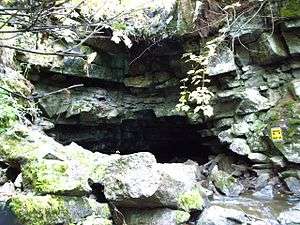
Trou du Diable entrance
The Trou du Diable (translated in English as Devil's Hole) is a cave situated in St-Casimir, in the province of Quebec, Canada. On the CanMatrix System (), you can find the Trou du Diable on the map Grondines (031-I/9) at the coordinates 22207325.
The Trou du Diable is in fact a creek of which the last 980 meters are underground, which makes it the second longest in Quebec. It is tributary of the Rivière Ste-Anne, about four kilometers upstream of St-Casimir.
Its highest point is 6.8 metres above the bottom of the cave, and at some places visitors have to crawl to move forward.
External links
- Description and images from Nichole Ouellette(in French)
- Tourist website about the trou du Diable(in French)
- Bougex Website about speleology(in French)
- Société québécoise de spéléologie(in French)
This article is issued from
Wikipedia.
The text is licensed under Creative Commons - Attribution - Sharealike.
Additional terms may apply for the media files.