| 1947 Pacific typhoon season |
|---|
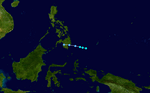
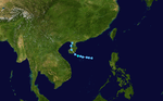
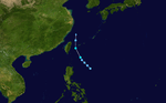
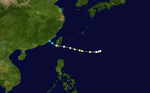
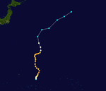
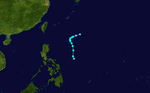
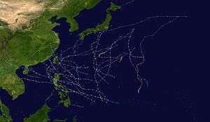 Season summary map |
| Seasonal boundaries |
|---|
| First system formed |
March 18, 1947 |
|---|
| Last system dissipated |
December 29, 1947 |
|---|
| Strongest storm |
|---|
|
|
| Name |
Rosalind |
|---|
| • Maximum winds |
240 km/h (150 mph)
(1-minute sustained) |
|---|
| • Lowest pressure |
924 hPa (mbar) |
|---|
|
|
| Seasonal statistics |
|---|
| Total storms |
27 |
|---|
| Typhoons |
19 |
|---|
| Super typhoons |
1 (unofficial) |
|---|
| Total fatalities |
Unknown |
|---|
| Total damage |
Unknown |
|---|
| Related articles |
|---|
|
|
|
The 1947 Pacific typhoon season has no official bounds; it ran year-round in 1947, but most tropical cyclones tend to form in the northwestern Pacific Ocean between June and December. These dates conventionally delimit the period of each year when most tropical cyclones form in the northwestern Pacific Ocean.
The scope of this article is limited to the Pacific Ocean, north of the equator and west of the international date line. Storms that form east of the date line and north of the equator are called hurricanes; see 1947 Pacific hurricane season. Tropical Storms formed in the entire west pacific basin were assigned a name by the Joint Typhoon Warning Center. Tropical depressions in this basin have the "W" suffix added to their number. Tropical depressions that enter or form in the Philippine area of responsibility are assigned a name by the Philippine Atmospheric, Geophysical and Astronomical Services Administration or PAGASA. This can often result in the same storm having two names.
Storms
Tropical Storm Anna
|
Tropical storm (SSHWS) |
|
|
| Duration |
March 18 – March 20 |
|---|
| Peak intensity |
65 km/h (40 mph) (1-min) 1001 hPa (mbar) |
|---|
Anna originated from a vigorous tropical wave that moved west along the ITCZ during the days of March 16 and 17. On March 18 an approaching cold front caused the wave to congeal into a tropical low pressure system while about 415 miles (670 km) to the east of Davao. The system rapidly organized into a tropical storm and continued west. Anna made landfall on Mindanao on March 20 as a tropical depression and weakened quickly thereafter.
Little data is available for this system, however, the U.S. Air Weather Service noted that the storm was of little significance.
Unnamed Storm
The IBTrACSBest Tracks website[1] lists an unnamed system of unknown strength forming near 11.4N 111.0E. The system is tracked from May 10–11
Unnamed Storm
The IBTrACSBest Tracks website[2] lists an unnamed system of unknown strength forming
near 9.6N 110.7E. The system is tracked from May 11–13
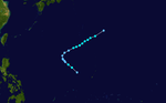
Typhoon Bernida
The Joint Typhoon Warning center (JTWC) best tracks[3] lists this system as 02W
|
Category 1 typhoon (SSHWS) |
|
|
| Duration |
May 13 – May 17 |
|---|
| Peak intensity |
150 km/h (90 mph) (1-min) 972 hPa (mbar) |
|---|
Unnamed Storm
The IBTrACSBest Tracks website[4] lists an unnamed system of unknown strength forming
near 20.7N 1077E. The system is tracked from May 17–19
Typhoon Carol
|
Category 3 typhoon (SSHWS) |
|
|
| Duration |
June 17 – June 23 |
|---|
| Peak intensity |
185 km/h (115 mph) (1-min) 960 hPa (mbar) |
|---|
Carol formed east of the Philippines on June 17. It moved northwest and skimmed right past the most northern island as a 115 mph typhoon. After that, it began to weaken. Carol passed by Taiwan, and was about to hit mainland China, but it suddenly took a northeast track. Shortly thereafter, Carol dissipated on June 23.
The Joint Typhoon Warning center (JTWC) best tracks[5] lists this system as 03W.
Tropical Storm Donna
The Joint Typhoon Warning center (JTWC) best tracks[6] lists this system as 04W
|
Tropical storm (SSHWS) |
|
|
| Duration |
July 8 – July 9 |
|---|
| Peak intensity |
65 km/h (40 mph) (1-min) 999 hPa (mbar) |
|---|
Tropical Storm Eileen
The Joint Typhoon Warning Center (JTWC) Best Tracks[7] lists this system as 05W
|
Tropical storm (SSHWS) |
|
|
| Duration |
July 17 – July 19 |
|---|
| Peak intensity |
65 km/h (40 mph) (1-min) 993 hPa (mbar) |
|---|
Tropical Storm Faith
|
Tropical storm (SSHWS) |
|
|
| Duration |
July 26 – July 31 |
|---|
| Peak intensity |
95 km/h (60 mph) (1-min) 998 hPa (mbar) |
|---|
Typhoon Gwen
|
Category 3 typhoon (SSHWS) |
|
|
| Duration |
August 4 – August 9 |
|---|
| Peak intensity |
185 km/h (115 mph) (1-min) 950 hPa (mbar) |
|---|
Typhoon Helena
|
Category 1 typhoon (SSHWS) |
|
|
| Duration |
August 12 – August 14 |
|---|
| Peak intensity |
130 km/h (80 mph) (1-min) 983 hPa (mbar) |
|---|
Typhoon Inez
|
Category 3 typhoon (SSHWS) |
|
|
| Duration |
August 26 – August 31 |
|---|
| Peak intensity |
185 km/h (115 mph) (1-min) 960 hPa (mbar) |
|---|
Tropical Storm Joyce
|
Tropical storm (SSHWS) |
|
|
| Duration |
September 8 – September 10 |
|---|
| Peak intensity |
65 km/h (40 mph) (1-min) 1000 hPa (mbar) |
|---|
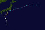
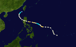
Typhoon Kathleen
|
Category 2 typhoon (SSHWS) |
|
|
| Duration |
September 10 – September 15 |
|---|
| Peak intensity |
165 km/h (105 mph) (1-min) 960 hPa (mbar) |
|---|
Typhoon Kathleen struck the Boso Peninsula and the entire Kanto Region in Japan on September 15. Heavy rains caused the Arakawa and Tone Rivers to overflow. The resulting floods killed 1,077 people and left 853 people missing.[8]
Typhoon Laura
|
Category 2 typhoon (SSHWS) |
|
|
| Duration |
September 14 – September 18 |
|---|
| Peak intensity |
165 km/h (105 mph) (1-min) 962 hPa (mbar) |
|---|
Typhoon Mildred
|
Category 1 typhoon (SSHWS) |
|
|
| Duration |
September 22 – September 25 |
|---|
| Peak intensity |
140 km/h (85 mph) (1-min) 985 hPa (mbar) |
|---|
Typhoon Nanette
|
Category 2 typhoon (SSHWS) |
|
|
| Duration |
September 29 – October 2 |
|---|
| Peak intensity |
165 km/h (105 mph) (1-min) 970 hPa (mbar) |
|---|
Typhoon Olive
|
Category 3 typhoon (SSHWS) |
|
|
| Duration |
October 2 – October 5 |
|---|
| Peak intensity |
205 km/h (125 mph) (1-min) 958 hPa (mbar) |
|---|
Typhoon Pauline
|
Category 3 typhoon (SSHWS) |
|
|
| Duration |
October 2 – October 8 |
|---|
| Peak intensity |
185 km/h (115 mph) (1-min) 958 hPa (mbar) |
|---|
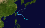
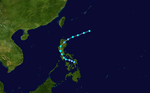
Super Typhoon Rosalind
|
Category 4 super typhoon (SSHWS) |
|
|
| Duration |
October 6 – October 14 |
|---|
| Peak intensity |
240 km/h (150 mph) (1-min) 918 hPa (mbar) |
|---|
The origins of Rosalind can be track on a tropical storm that intensified into a category 2 on October 6 and named Rosalind. Therefore, Rosalind continued to rapidly intensify from 964 to 918 mbar, reaching its peak intensity. After Rosalind reaches its peak intensity, slight wind shear causes Rosalind to weaken on a category 2 on October 10. It intensified into a category 3 before it moved slowly. It weakened to a category 1 and tropical storm. Rosalind dissipated on October 14.
Rosalind was the first super typhoon ever recorded in the Pacific Ocean.
Typhoon Alice
|
Category 4 typhoon (SSHWS) |
|
|
| Duration |
October 13 – October 21 |
|---|
| Peak intensity |
220 km/h (140 mph) (1-min) 940 hPa (mbar) |
|---|
Tropical Storm Beatrice
|
Tropical storm (SSHWS) |
|
|
| Duration |
October 16 – October 21 |
|---|
| Peak intensity |
85 km/h (50 mph) (1-min) 991 hPa (mbar) |
|---|
Typhoon Cathy
|
Category 3 typhoon (SSHWS) |
|
|
| Duration |
October 29 – November 4 |
|---|
| Peak intensity |
185 km/h (115 mph) (1-min) 965 hPa (mbar) |
|---|
Typhoon Dora
|
Category 3 typhoon (SSHWS) |
|
|
| Duration |
November 2 – November 10 |
|---|
| Peak intensity |
185 km/h (115 mph) (1-min) 965 hPa (mbar) |
|---|
Tropical Storm Elnora
|
Tropical storm (SSHWS) |
|
|
| Duration |
November 10 – November 12 |
|---|
| Peak intensity |
95 km/h (60 mph) (1-min) 995 hPa (mbar) |
|---|
Typhoon Flora
|
Category 3 typhoon (SSHWS) |
|
|
| Duration |
November 13 – November 19 |
|---|
| Peak intensity |
185 km/h (115 mph) (1-min) 963 hPa (mbar) |
|---|
Typhoon Gladys
|
Category 1 typhoon (SSHWS) |
|
|
| Duration |
November 17 – November 22 |
|---|
| Peak intensity |
140 km/h (85 mph) (1-min) 987 hPa (mbar) |
|---|
Typhoon Hannah
|
Category 3 typhoon (SSHWS) |
|
|
| Duration |
November 22 – November 23 |
|---|
| Peak intensity |
185 km/h (115 mph) (1-min) 955 hPa (mbar) |
|---|
Tropical Storm Irene
|
Tropical storm (SSHWS) |
|
|
| Duration |
November 30 – December 3 |
|---|
| Peak intensity |
85 km/h (50 mph) (1-min) 1000 hPa (mbar) |
|---|
Tropical Storm Irene formed on November 30 between the Philippine Islands. It strengthened to a tropical storm with 50 mph winds before it made landfall on one of the islands. It curved northeast and weakened to a tropical depression. But after exiting land, it restrengthened to a moderate tropical storm. But shortly thereafter, it became extratropical on December 3. The Japan Meteorological Agency analyzed it as a tropical depression, though it was actually a moderate tropical storm.
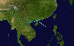
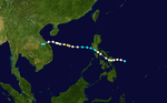
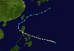
Typhoon Jean
|
Category 2 typhoon (SSHWS) |
|
|
| Duration |
December 22 – December 29 |
|---|
| Peak intensity |
175 km/h (110 mph) (1-min) 973 hPa (mbar) |
|---|
Typhoon Jean struck the southern portion of the National Capital Region "NCR" "Metro Manila" with the northern eyewall or central circulation encompassing some of the southern portions of the Capital Manila.
The Typhoon struck Metro Manila during Christmas after forming in the Philippine sea moving West-northwest and accelerating as it makes landfall in the border area of Albay and Camarines sur. The storm continued its fast movement and track towards southern Manila.
After passing Manila the storm emerges from the coast of Zambales towards the south china sea starting to shift more towards the Northwest and eventually North and Northeast. All the way moving parallel to the coast of Luzon. The typhoon weakened into a tropical storm and recurved west of Batanes island and passed through the Bashi channel south of Taiwan and continued North-eastward towards Miyakojima and the southern Japanese islands and eventually dissipating on the 29th of December. No data is available on what happened to the system after turning post-tropical.
The curved track of Typhoon Jean is somewhat similar to that of Typhoon Flora the month before.
Because Typhoon Jean battered Manila during Christmas there were reports of Christmas decorations being strewn around the city.
There were also reports of wind damage in Parañaque city. It was the first recorded incident of Typhoons impacting the country at the time of Christmas with the others being Typhoon Lee in 1981 and Typhoon Nock-Ten in 2016 and an Unnamed typhoon in 1918.