Oklahoma Tribal Statistical Area
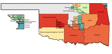
Map of Oklahoma Tribal Statistical Areas
Oklahoma Tribal Statistical Area is a statistical entity identified and delineated by federally recognized American Indian tribes in Oklahoma as part of the U.S. Census Bureau's 2010 Census and ongoing American Community Survey.[1] Some of these areas are also formally recognized as reservations,[2] while the reservation status of others is less certain. Many of these areas are also designated Tribal Jurisdictional Areas,[3] areas within which tribes will provide government services and assert other forms of government authority.
List
- Caddo-Wichita-Delaware OTSA
- Cherokee OTSA
- Cheyenne-Arapaho OTSA
- Chickasaw OTSA
- Choctaw OTSA
- Citizen Potawatomi Nation-Absentee Shawnee OTSA
- Creek OTSA
- Eastern Shawnee OTSA
- Iowa OTSA
- Kaw OTSA
- Kickapoo OTSA
- Kiowa-Comanche-Apache-Fort Sill Apache OTSA
- Miami OTSA
- Modoc OTSA
- Otoe-Missouria OTSA
- Ottawa OTSA
- Pawnee OTSA
- Peoria OTSA
- Ponca OTSA
- Quapaw OTSA
- Sac and Fox OTSA
- Seminole OTSA
- Seneca-Cayuga OTSA
- Tonkawa OTSA
- Wyandotte OTSA
Joint Use Areas
See also
References
- ↑ Geography, US Census Bureau. "2010 Census Tribal Statistical Areas Program". www.census.gov. Retrieved 2017-09-19.
- ↑ "Murphy v. Royal, No. 07-7068 (10th Cir. 2017)". Justia Law. Retrieved 2017-09-19.
- ↑ "Characteristics of American Indians and Alaska Natives Participating in Temporary Assistance for Needy Families Programs: Background." US Dept. of Health and Human Services: Office of the Assistant Secretary for Planning and Evaluation. April 2009 (retrieved 21 May 2011)
External links
This article is issued from
Wikipedia.
The text is licensed under Creative Commons - Attribution - Sharealike.
Additional terms may apply for the media files.