Tri-State district
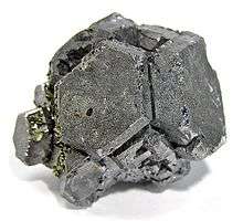
An unusual cluster of galena crystals from the Tri-State district. The gold-colored mineral is chalcopyrite. Size: 3.9 x 3.4 x 2.5 cm.
The Tri-State district was an historic lead-zinc mining district located in southwest Missouri, southeast Kansas and northeast Oklahoma. The district produced lead and zinc for over 100 years. Production began in the 1850s and 1860s in the Joplin - Granby area of Jasper and Newton counties of southwest Missouri and continued until the closure of the Picher, Oklahoma mines in 1967.[1][2] The tri-state district includes three mining-related Superfund sites: the Tar Creek Superfund site in Oklahoma; the Jasper County and Newton County sites in Missouri; and the Cherokee County site in Kansas. [3]
See also
References
| Wikimedia Commons has media related to Minerals of Tri-State District. |
- ↑ Brockie, Douglas C., et al., The Geology and Ore Deposits of the Tri-State District of Missouri, Kansas and Oklahoma, in Ridge, John D., Ore Deposits of the United States, 1933-1967; Vol 1, Ch. 20, pp. 400 - 430, 1968, American Institute of Mining, Metallurgical, and Petroleum Engineers, Inc.
- ↑ http://digital.library.okstate.edu/encyclopedia/entries/T/TR014.html TRI-STATE LEAD AND ZINC DISTRICT, Oklahoma Historical Society
- ↑ http://www.sagchip.org/planning/NRDR/pdf/TriStateMining.pdf
External links
- Lead and Zinc Mining in Kansas, Kansas Geological Survey
- Cherokee County Map, Kansas
- Ottawa County Map, Oklahoma
Coordinates: 37°00′N 94°30′W / 37.0°N 94.5°W
This article is issued from
Wikipedia.
The text is licensed under Creative Commons - Attribution - Sharealike.
Additional terms may apply for the media files.