Traun (river)
| Traun | |
|---|---|
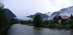 Traun River near Obertraun | |
| Country | Austria |
| Physical characteristics | |
| Main source | Totes Gebirge range |
| River mouth |
Danube (Linz) 47°54′58″N 13°48′20″E / 47.91611°N 13.80556°ECoordinates: 47°54′58″N 13°48′20″E / 47.91611°N 13.80556°E |
| Length | 155.9 km (96.9 mi) [1] |
| Discharge |
|
| Basin features | |
| Progression | Danube→ Black Sea |
Traun (German: [ˈtʁaʊn] (![]()
Until the late 19th century, it was only possible to reach Hallstatt by boat or via narrow trails. However this secluded and inhospitable landscape nevertheless counts as one of the first places of human settlement due to the rich sources of natural salt, which was mined for thousands of years, originally in the shape of hearts. Some of Hallstatt's oldest archaeological finds, such as a shoe-last celt - a long thin stone tool used to fell trees and to work wood - date back to around 5000 B.C. One of the first blacksmith's sites was excavated there. Active trade and thus wealth allowed for the development of a highly sophisticated society, hence the term Hallstatt culture.
In 1846, a large prehistoric cemetery was discovered close by the current location of Hallstatt. There is little room for cemeteries so every ten years bones used to be exhumed and removed into an ossuary to make room for new burials. A collection of elaborately decorated skulls with the owners' names, professions, death dates inscribed on them is on display at the local chapel.
References
- ↑ DORIS Atlas (Upper Austria)
External links
| Wikimedia Commons has media related to Traun. |
Gallery
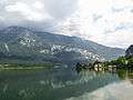 The river Traun between Au and Steeg
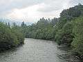 The Traun near Lauffen