Torotoro National Park
| Torotoro National Park | |
|---|---|
|
IUCN category II (national park) | |
 Torotoro Canyon | |
 | |
| Coordinates | 18°6′S 65°46′W / 18.100°S 65.767°WCoordinates: 18°6′S 65°46′W / 18.100°S 65.767°W |
| Area | 165 km2 |
| Established | National Park 1989 |
Torotoro National Park (Spanish "Parque Nacional Torotoro and in Quechua the name ToroToro meaning mud") is a small national park and ancient town in Bolivia founded about 250 years ago by the Quechuas and the Spanish. It is situated among the eastern mountain ranges of the South American Andes cordilleras in the area of Potosi Bolivia.
Geography
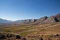
Torotoro National Park is situated in the northern Potosí department, 140 km south of Cochabamba and only accessible by old rock roads and newly paved roads that start at cochabamba. It takes about four hours in any season with buses departing daily at cochabamba. Torotoro National Park covers 165 km2 and is located at 18° 7' S and 65° 46' W in a semi-arid landscape and has altitudes between 2000 and 3500 m above sea level, with canyons as deep as 300 meters. The popular park established in 1989 is known for its ancient history like ocean sealife fossils, cave paintings, canyons, dinosaur footprints and much more.
Places of interest
The Torotoro National Park offers old woodland and warm temperatures with beautiful valleys and the only species of endangered red-fronted rainbow macaw found in South America, as well as typical features of karst terrain like caves and dolines, Paleozoic and Cretaceous calcitic deposits with fossils, and panoramic landscapes eroded by wind and waters. Among the main features of the park are:
- Uma Jalanta cave, four miles northwest of the town of Torotoro, 4,600 m long and 164 m deep, one of the longest and deepest caves in Bolivia, with stalactites and stalagmites, blind fish and waterfalls.
- Dinosaur bone fragments and more than 2,500 dinosaur footprints, of biped and quadruped dinosaurs, theropods and sauropods from the cretaceous period 120 million years ago.
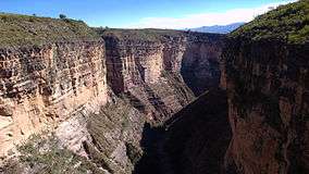
- The Vergel or Waka Sinqa Canyon with waterfalls and pools and lush tropical vegetation.
- Llama Chaki, an archaeological site southeast of the town of Torotoro with remnants of the Quechua culture.
Galerie
 Rock formations ToroToro, Bolivia
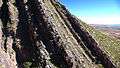 Siete Vueltas
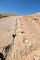 Dinosaur footprints in ToroToro National Park