Tinguiririca Volcano
| Tinguiririca Volcano | |
|---|---|
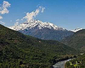 The Tinguiririca volcano seen from the Tinguiririca river valley. The fumarole from its summit crater can be clearly seen. | |
| Highest point | |
| Elevation | 4,280 m (14,040 ft) |
| Coordinates | 34°48′49″S 70°21′07″W / 34.81361°S 70.35194°W |
| Geography | |
| Location | Chile |
| Parent range | Andes |
| Geology | |
| Mountain type | Stratovolcano |
| Last eruption | 1917 |
Tinguiririca Volcano is a massive and active stratovolcano located in Chile's VI Region (O'Higgins) and near the Argentinian border. Constant fumarolic activity occurs within and on the NW wall of its summit crater and hot springs and fumaroles can also be seen on the western flanks, as illustrated by the image on the right. It was near this volcano that the Uruguayan Air Force Flight 571 crashed in 1972 with its survivors lost for seventy-two days.
See also
References
This article is issued from
Wikipedia.
The text is licensed under Creative Commons - Attribution - Sharealike.
Additional terms may apply for the media files.