Thur (France)
| Thur | |
|---|---|
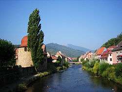 The Thur in Thann. | |
| Country | France |
| Physical characteristics | |
| Main source |
Vosges mountains ±950 m (3,120 ft) |
| River mouth |
river Ill 47°52′32″N 7°20′34″E / 47.87556°N 7.34278°ECoordinates: 47°52′32″N 7°20′34″E / 47.87556°N 7.34278°E |
| Length | 53 km (33 mi) |
| Discharge |
|
| Basin features | |
| Basin size | 262 km2 (101 sq mi) |
The Thur is a river in the Haut-Rhin department, Alsace, France, left tributary of the river Ill. It rises in the Vosges Mountains, and flows through the towns Thann and Cernay. It flows into the Ill (a tributary of the Rhine) near Ensisheim, north of Mulhouse.
References
This article is issued from
Wikipedia.
The text is licensed under Creative Commons - Attribution - Sharealike.
Additional terms may apply for the media files.