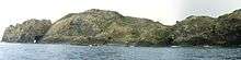
Three Kings Islands
| Manawatāwhi or Ngā Motu Karaka | |
|---|---|
 Three Kings Islands | |
| Geography | |
| Coordinates | 34°09′14″S 172°8′24″E / 34.15389°S 172.14000°ECoordinates: 34°09′14″S 172°8′24″E / 34.15389°S 172.14000°E |
| Total islands | 13 |
| Area | 4.86 km2 (1.88 sq mi) |
| Highest elevation | 295 m (968 ft) |
| Administration | |
| Demographics | |
| Population | None |
The Three Kings Islands, called Manawatāwhi by Māori, are a group of 13 uninhabited islands about 55 kilometres (34 mi) northwest of Cape Reinga, New Zealand, where the South Pacific Ocean and Tasman Sea converge. They measure about 4.86 km² in area. The islands are situated on a submarine plateau, the Three Kings Bank, and are separated from the New Zealand mainland by an 8 km wide, 200 to 300 m deep submarine trough. Therefore, despite relative proximity to the mainland, the islands are listed with the New Zealand Outlying Islands. The islands are an immediate part of New Zealand, but not part of any region or district, but instead Area Outside Territorial Authority, like all the other outlying islands except the Solander Islands.
History
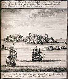
They were named Drie Koningen Eyland on 6 January 1643 by Dutch explorer Abel Janszoon Tasman who three weeks earlier had become the first European known to have seen New Zealand.
Tasman anchored at the islands when searching for water. As it was the Twelfth Night feast of the Epiphany, the day the biblical three kings known as the wise men visited Christ the child, he named the islands accordingly. Tasman also named another prominent cape Cape Maria van Diemen, after the wife of Anthony van Diemen, Governor-General of the Dutch East Indies (now Indonesia). These are the only two geographic features in New Zealand to retain the names given to them by Abel Tasman. Tasman found the islands to be inhabited by Māori, but since 1840 they have been uninhabited. The Māori population probably never exceeded 100.
In 1945, G. T. S. Baylis made an amazing discovery on Three Kings when he found the last remaining specimen anywhere of a tree which is now called Pennantia baylisiana, a Kaikomako. It was recognised internationally as the world's rarest and thus most endangered tree. Extremely careful propagation in New Zealand has resulted in the species being reliably established, but it continues to be carefully monitored. The islands were made a wildlife sanctuary in 1995. Other plants endemic to the islands include Tecomanthe speciosa and Elingamita johnsonii.
Geography

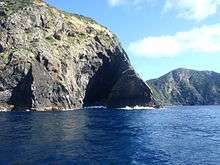
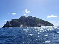
The Three Kings group falls into two subgroups with four main inhospitable islands and a number of smaller rocks on a submarine plateau called King Bank which rises out of extremely deep water. The surrounding sea has very clear visibility and contains teeming fish life, attracting hundreds of divers. Another attraction is the wreck of the Elingamite which foundered there on 9 November 1902.
King Group
- With 4.04 km² Great Island or King Island, is by far the largest. A northeastern peninsula, with an area of about 1 km², is almost cut off by a 200 m wide but more than 80 m high isthmus formed by North West Bay and South East Bay. The island reaches an elevation of 295 m in the western part, while the peninsula is up to 184 m high near its western cliffs.
- North East Island, official name Oromaki/North East Island, about 1 km northeast of Great Island, is 0.10 km² in size and reaches a height of 111 m.
- Farmers Rocks, 0.8 km east of Great Island, are 5 metres high and just a few hundred square metres in size.
Southwest Group
- South West Island, official name Moekawa/South West Island, at 0.38 km², is the second largest of the Three Kings Islands and is 207 m high. It is located about 4.5 km southwest of Great island.
- The Princes Islands, seven small islets and numerous rocks with a total area of about 0.2 km², start 600 m west of South West Island and stretch about 1.8 km east-west. The north-eastern islet is the highest at 106 m. The smallest islet is Rosemary Rock.
- West Island, official name Ōhau/West Island, at 0.16 km² the third largest island, is 500 m southwest of the westernmost of the Princes Islands. It is 177 m high. The island plays an important part in the traditional Māori belief that the spirits of dead Māori return to their Pacific homeland of Hawaiki. Near Cape Reinga on the mainland, sometimes translated as the underworld, is a gnarled Pōhutukawa tree reputed to be more than 800 years old. The spirits are believed to journey to the tree and down its roots into the sea bed. They are said to surface again on Ohau and say a last farewell to New Zealand before going on to Hawaiki.
Flora and fauna
fauna
Nature reserve
Three Kings Island is a nature reserve administered by the Department of Conservation
References
- Topographic maps of New Zealand
- Nautical description (see page 211)
External links
| Wikimedia Commons has media related to Three Kings islands. |
