The World's End, Chelsea
| The World's End | |
|---|---|
 The World's End | |
 The World's End  The World's End | |
| General information | |
| Address | 459 King's Road, Chelsea |
| Town or city | London |
| Country | England |
| Coordinates | 51°28′55″N 0°10′47″W / 51.48194°N 0.17972°WCoordinates: 51°28′55″N 0°10′47″W / 51.48194°N 0.17972°W |
| Completed | 1897 |
| Designations | |
Listed Building – Grade II | |
| Official name | The World's End Distillery |
| Designated | 28 April 2006 |
| Reference no. | 1391649 |
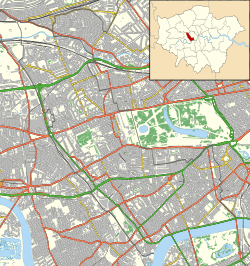
The World's End is a Grade II listed public house and restaurant at 459 King's Road, Chelsea, London.[1] It gives its name to the surrounding area at the western end of the King's Road.
History
It was built in 1897, but the architect is not known.[1] Historic England calls it "a fine example of a public house in the gin-palace genre".[1]
The current building replaced earlier buildings, one of which is shown on the north side of Kings Road on the 1795 map; Cary's New And Accurate Plan Of London And Westminster.[2] The old tavern was a noted house of entertainment in the reign of Charles II. The grounds and tea gardens were extensive and it was elegantly fitted out. The house was probably called "The World's End" because of its then considerable distance from London and the bad and dangerous state of the roads leading to it. As it stood close to the River Thames most of the visitors made the journey by boat.[3]
Earlier buildings
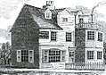 The World's End Tavern, c.1790
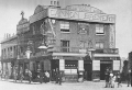 The Olde World's End Tavern, c.1894
See also
References
| Wikimedia Commons has media related to Worlds End, Chelsea. |
- 1 2 3 Historic England. "Worlds End Distillery public house (1391649)". National Heritage List for England. Retrieved 3 April 2015.
- ↑ "MAPCO Map And Plan Collection Online : Cary's New And Accurate Plan Of London And Westminster 1795". mapco.net. Retrieved 30 July 2017.
- ↑ Walford, Edward (1878). Old and New London. 5. London: Cassell, Petter & Galpin. p. 87. Retrieved 28 November 2017.
External links
- Worlds End, 459 Kings Road, Chelsea, London (UK Pub history research and London historical street directory)