Bouladuff
| Bouladuff An Bhuaile Dhubh | |
|---|---|
| Village | |
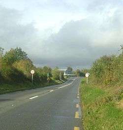 Entrance to Bouladuff R498 | |
 Bouladuff Location in Ireland | |
| Coordinates: 52°43′02″N 7°54′40″W / 52.717112°N 7.911179°WCoordinates: 52°43′02″N 7°54′40″W / 52.717112°N 7.911179°W | |
| Country |
|
| Province | Munster |
| County | County Tipperary |
| Population (2011 Census) | 409 |
Bouladuff (Irish: An Bhuaile Dhubh),[1] also known as Inch and The Ragg,[2] is a village near Thurles in County Tipperary, Ireland. According to the CSO census of 2011, the population is 409 a reduction of 43 people since the previous Census in 2006. It is in the barony of Eliogarty.
Location and access
It lies 5 miles from Thurles and 3 miles from Borrisoleigh. The village is set in the Suir valley and bounded by the Silvermine Mountains to the northwest and the Slieveardagh hills to the Southeast. The main road is the R498 regional road from Nenagh to Thurles. The area around Bouladuff is rich and varied in scenery with views of the Devils Bit and Tower mountains.
Amenities
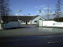
Drom and Inch GAA Club Bouladuff
- Inch National school
- Inch Church (200 years old)
- A nightclub and Bar
- Petrol Station and Shop
- Inch Community Hall
- Restaurant and B&b
- GAA grounds of the Drom-Inch GAA club, complete with dressing room and a covered stand
- Bouladuff Cemetery
- Inch old graveyard
See also
Notes
Putting the barony in its historico-geographical context.
- Barony - an old administrative division. Eliogarty - one of 14 baronies in the old county, between Ikerrin to the north (whose chief town is Roscrea), Kilnamanagh Upper to the west (whose chief town is Borrisoleigh) and Middle Third to the south (whose chief town is Cashel).
External links
Gallery
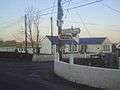 Inch National School
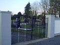 Bouladuff Cemetery
References
- ↑ "Placenames Database of Ireland". Dublin City University. Retrieved 6 February 2015.
- ↑ "Moves Afoot to Inch Out The Ragg". Tipperary Star. 21 June 2008. Archived from the original on 13 September 2012. Retrieved 2008-11-17.
This article is issued from
Wikipedia.
The text is licensed under Creative Commons - Attribution - Sharealike.
Additional terms may apply for the media files.