The Paseo (Kansas City, Missouri)
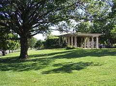
The Paseo (also known as Paseo Boulevard or Paseo) is a major north–south parkway in Kansas City, Missouri. It runs 19 miles (31 km) (85 blocks) in the center of the city: from Cliff Drive and Lexington Avenue on the bluffs above the Missouri River in the Pendleton Heights historic neighborhood, to 85th Street and Woodland Avenue. The parkway holds 223 acres (0.90 km2) of boulevard parkland dotted with several Beaux-Arts-style decorative structures and architectural details maintained by the city's Parks and Recreation department.[1]
The name for Kansas City's first major boulevard was suggested by the first President of the Parks Board, August R. Meyer (1851-1905), based on the Paseo de la Reforma in Mexico City.[2]
Background
Kansas City's extensive parkway and boulevard system is part of the City Beautiful Movement. The Paseo parkway is modeled on the Paseo de la Reforma in Mexico City; from which it takes its name.[3] From its start at Cliff Drive, the original alignment changed to install the on-ramp to Interstate 35, it curves slightly southwest before heading almost due south for most of its length. A few city parks are located adjacent to The Paseo, such as Parade Park (Truman Road & The Paseo) and Troost Park (31st Street & The Paseo).
The parkway was laid out in the early 1900s by George Kessler under the direction of August Robert Meyer, first president of the Commission of Parks. The Paseo, conceived as a series of small parks, extended through a former slum area and contained intersections that featured a formal sunken garden, a pergola, and large fountains reminiscent of those at Versailles.[4][5][6] Its construction was preceded by the eviction of African-American families that had to move to other overcrowed slums.[7] Its northern end acquired an unsavory reputation during the early 1920s owing to the spread of prostitution, gambling and narcotics in the area.[8] In the 1920, with the re-emergence of the African-American population in the surrounding areas, the Paseo stood out as "ribbon of white in an otherwise black village", with more than half the white population living in the area having a Paseo address.[9]
The Paseo intersects with US 71, US 40, I-70, US 24, and US 56. The Christopher S. Bond Bridge (which replaced the defunct Paseo Bridge in 2010) does not actually carry The Paseo boulevard but features direct north-south access onto the road via appropriate exit-entrance ramps. Trucks are prohibited from using the Paseo.
Points of interest along The Paseo
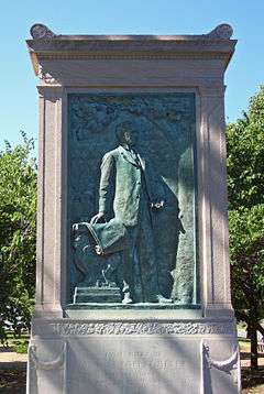
- A Daniel Chester French sculpture honoring Meyer, dedicated in 1909, stands at 10th and Paseo.
- Dr. Generous Henderson House, designed by Rudolf Markgraf in 1899, is the only remaining example of Second Renaissance Revival style in Kansas City, on the National Register of Historic Places, at 1016 The Paseo.
- The 18th and Vine Historic District, on the National Register of Historic Places.
- "Bird Lives," statue honoring Charlie "Bird" Parker, jazz saxophone player, by Robert Graham, at 17th Terrace.
- The Paseo YMCA, plans for the future home of the Buck O'Neil Education Research Center.
- Troost Lake and park, located at 27th Street.
- Scottish Rite Temple, monumental Beaux-Arts/Egyptian Revival civic auditorium, designed by Keene and Simpson (1930), at Linwood Boulevard.
- Stoplight, unusual signal made of cut-stone in the middle of the intersection designed by Edward Buehler Delk (1931), at Linwood Boulevard.
- Keneseth Israel-Beth Shalom Synagogue (now Christ Temple Church), colorful twin mosaic domes on a Byzantine-style building, by Greenbaum, Hardy, and Schumacher (1927), at 34th Street.
- Faxon Montessori, located at Linwood Boulevard (32nd Street).
- Gates Bar-B-Q restaurant on Cleaver II Boulevard at Paseo. The headquarters are located at 4621 Paseo. (The former Gates Bar-B-Q headquarters was at Volker Boulevard.)
- Children's Mercy Teen Clinic, at 46th Street. (Moved to 3101 Broadway)
- Rockhurst University, from Rockhurst Road (52nd Street) to 54th Street.
- "PASEO" Rocks and Stairs, At Volker Blvd, leading up to the old Paseo High School, now Paseo Academy.
- Brush Creek, from Emanuel Cleaver II Boulevard to Volker Boulevard.
- The Landing Mall, located at 63rd Street.
- Nazarene Theological Seminary and formerly the location of the Church of the Nazarene World Headquarters, at Meyer Boulevard. The site of the old headquarters is now Ewing Marion Kauffman School
School.
- Route 85-Paseo travels on parts of Paseo between Armour Boulevard (35th Street) and 85th Street. (formerly Route 54-Armour/Paseo)
Sites named after The Paseo
- Paseo Bridge, near its starting point.
- Paseo Academy, a magnet performing arts high school formerly known as Paseo High School.
- Route 85-Paseo, a city transportation bus route.
- Paseo YMCA, a historic YMCA that is part of a renovation plan.
See also
References
- ↑ Kansas City, Missouri Parks & Recreation, 2008 Reference Book, "Parkways," p. 24. Archived 2009-03-25 at the Wayback Machine.
- ↑ https://dnr.mo.gov/shpo/nps-nr/79001368.pdf
- ↑ Isaacson, Darlene (2003). Kansas City In Vintage Postcards. Charleston, SC: Arcadia Publishing. p. 84. ISBN 978-0738531793.
- ↑ Scott, Mel (1972). American City Planning Since 1890. Berkeley: University of California Press. p. 15. ISBN 978-0520020511.
- ↑ Tishler, William H. (2004). Midwestern Landscape Architecture. Urbana: University of Illinois Press. p. 105. ISBN 978-0252072147.
- ↑ Haskell, Harry (2007). Boss-busters and Sin Hounds: Kansas City and Its Star. Columbia: University of Missouri Press. pp. 52, 56, 60–2, 72, 75–7. ISBN 978-0826217691.
- ↑ Sherry Lamb Schirmer (2002). A City Divided: The Racial Landscape of Kansas City, 1900-1960. University of Missouri Press. pp. 16–17. ISBN 978-0-8262-1391-4.
- ↑ Sherry Lamb Schirmer (2002). A City Divided: The Racial Landscape of Kansas City, 1900-1960. University of Missouri Press. p. 20. ISBN 978-0-8262-1391-4.
- ↑ Sherry Lamb Schirmer (2002). A City Divided: The Racial Landscape of Kansas City, 1900-1960. University of Missouri Press. p. 45. ISBN 978-0-8262-1391-4.