The Bottom
| The Bottom | |
|---|---|
| Town | |
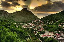 The Bottom, with the campus of the School of Medicine at the bottom right | |
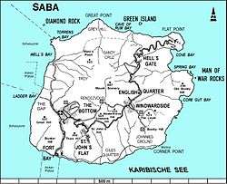 Map of Saba showing The Bottom | |
| Coordinates: 17°37′34″N 63°14′57″W / 17.62611°N 63.24917°WCoordinates: 17°37′34″N 63°14′57″W / 17.62611°N 63.24917°W | |
| Country |
|
| Public body |
|
| Population | |
| • Total | 462 |
| Time zone | UTC-4 (AST) |
| Climate | Aw |
The Bottom (formerly Botte) is the capital and largest town of the island of Saba,[1] the Caribbean Netherlands, and is the first stop on the way from Saba's Port in Fort Bay towards the rest of the island. It has approximately 500 inhabitants of the total 1,991 islanders.
History
The original name of the town was De Botte, old Dutch for "The Bowl", referring to its geographical position in a valley surrounded by the various Mountains. "The Bottom" is an English corruption of this name.
Climate
| Climate data for The Bottom, Saba (1971–2000) | |||||||||||||
|---|---|---|---|---|---|---|---|---|---|---|---|---|---|
| Month | Jan | Feb | Mar | Apr | May | Jun | Jul | Aug | Sep | Oct | Nov | Dec | Year |
| Record high °C (°F) | 30.4 (86.7) |
30.8 (87.4) |
30.7 (87.3) |
31.7 (89.1) |
31.9 (89.4) |
32.5 (90.5) |
32.8 (91) |
33.2 (91.8) |
33.2 (91.8) |
32.1 (89.8) |
32.0 (89.6) |
31.1 (88) |
33.2 (91.8) |
| Average high °C (°F) | 28.1 (82.6) |
27.7 (81.9) |
28.3 (82.9) |
29.2 (84.6) |
30.0 (86) |
30.4 (86.7) |
30.5 (86.9) |
30.9 (87.6) |
30.8 (87.4) |
30.4 (86.7) |
29.8 (85.6) |
28.6 (83.5) |
29.6 (85.3) |
| Daily mean °C (°F) | 25.7 (78.3) |
25.3 (77.5) |
25.7 (78.3) |
26.6 (79.9) |
27.4 (81.3) |
28.1 (82.6) |
28.1 (82.6) |
28.5 (83.3) |
28.5 (83.3) |
28.2 (82.8) |
27.4 (81.3) |
26.3 (79.3) |
27.2 (81) |
| Average low °C (°F) | 24.1 (75.4) |
23.6 (74.5) |
23.9 (75) |
24.7 (76.5) |
25.6 (78.1) |
26.2 (79.2) |
26.0 (78.8) |
26.4 (79.5) |
26.5 (79.7) |
26.3 (79.3) |
25.4 (77.7) |
24.7 (76.5) |
25.3 (77.5) |
| Record low °C (°F) | 20.8 (69.4) |
20.0 (68) |
21.4 (70.5) |
22.1 (71.8) |
22.6 (72.7) |
23.1 (73.6) |
21.8 (71.2) |
22.0 (71.6) |
22.4 (72.3) |
22.4 (72.3) |
22.6 (72.7) |
21.3 (70.3) |
20.0 (68) |
| Average rainfall mm (inches) | 36.8 (1.449) |
75.3 (2.965) |
35.4 (1.394) |
28.1 (1.106) |
95.9 (3.776) |
44.4 (1.748) |
60.8 (2.394) |
77.0 (3.031) |
60.5 (2.382) |
35.5 (1.398) |
134.5 (5.295) |
76.5 (3.012) |
760.5 (29.941) |
| Average rainy days (≥ 1.0 mm) | 10.3 | 10.3 | 6.3 | 4.0 | 6.7 | 5.8 | 5.8 | 6.3 | 7.3 | 3.5 | 10.0 | 9.7 | 86.0 |
| Average relative humidity (%) | 82.0 | 82.3 | 78.2 | 78.8 | 78.0 | 81.9 | 84.5 | 88.8 | 87.4 | 81.2 | 71.1 | 74.5 | 80.7 |
| Source: Meteorological Department Curaçao[2] | |||||||||||||
Infrastructure
The Bottom is home to the government offices, a hospital, a nursing home, a sports field, three churches, a library, various shops and the 200 students of the Saba University School of Medicine.[1]
Events
As capital of the island, The Bottom hosts a number of events throughout the year. During the summer the 'Saba Carnival' is held here. It's a parade full of colour accompanied with the music of steel drums and local artists. It is a highly anticipated event on the Saban calendar as most of the island meets together to dance, sing and enjoy the festival. The Saba Carnival usually lasts for a few days in which the island focuses on The Bottom.
Another event held in the Bottom is 'Saba Day'. This is the national day of the island in which all offices, schools and stores are closed. The island celebrates its diversity and culture through various activities and parades. The Bottom holds host to a concert at the sports field where local and other Caribbean artists come to perform. There are fishing competitions at sea, drawing competitions for children etc.
Gallery
.jpg)
.jpg)
See also
References
- 1 2 The villages of Saba (Saba Tourist Bureau)
- ↑ "The Bottom, Saba: Summary of Climatological Data, Period 1971-2000" (PDF). Meteorological Department Curaçao. Retrieved 22 September 2016.
External links
![]()
| Populated places | |||
|---|---|---|---|
| Transport | |||
| Education | |||
| Heraldry | |||