Texas Triangle
| Texas Triangle Megaregion | |
|---|---|
| Megaregion of the U.S. | |
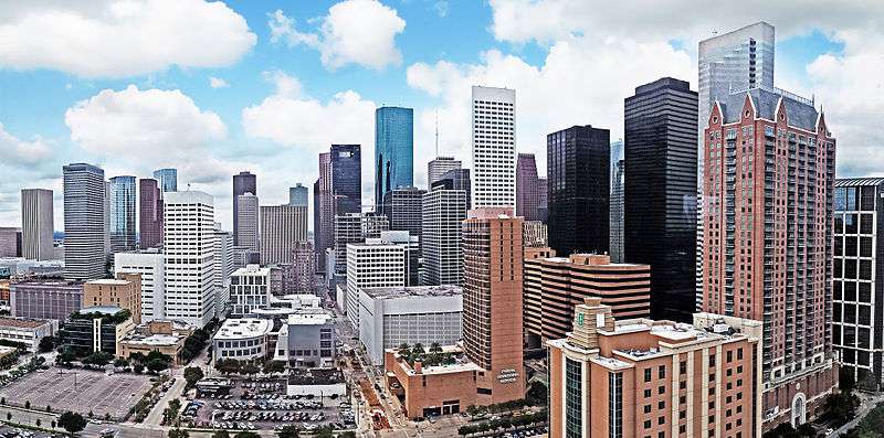 Houston | |
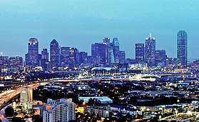 Dallas | |
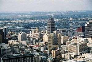 San Antonio | |
| Country |
|
| State(s) |
|
| Population | 17,745,584 [1] |
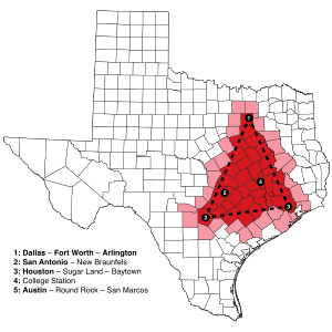
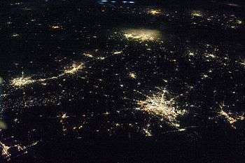
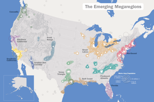
The Texas Triangle is one of eleven megaregions in the United States. These are urban areas that are much greater in scale than a metropolitan statistical area (MSA), defined by the US Census Bureau. These regions also are known as megapolitan areas. The Texas Triangle is formed by the four main cities, Houston, Dallas-Fort Worth, San Antonio, and Austin, connected by Interstate 45, Interstate 10, and Interstate 35. The area is sometimes also referred to as the Texaplex.[2]
Growth
In 2004, the Texas Triangle contained 5 of the 20 biggest cities in the US, and was home to more than 70% of all Texans, with a population of 13.8 million.[3] In the next 40 years, the population of the Texas Triangle has been projected to grow more than 65%,[4] or an additional ten million people, leading to 78% of Texans living and working within the Texas Triangle. From a resident's perspective, the Triangle is gradually becoming synonymous with Texas.[5]
The Triangle is anchored by the metropolitan areas of Houston, Dallas–Fort Worth, and San Antonio. Additional MSAs in the region include Austin, Bryan-College Station, Killeen-Temple-Fort Hood, and Waco. Twelve micropolitan statistical areas are within the Triangle, which includes 66 counties.[6] Beaumont, located east of Houston, has been considered part of the Texas Triangle by numerous studies dating from 2000.[7][8][9][10][11] Burleson County is the center of the Texas Triangle.
Sizable metro areas in Texas outside the Triangle are Corpus Christi, El Paso, Lubbock, Midland-Odessa, Abilene, San Angelo, Laredo, Amarillo, Tyler, Longview, Wichita Falls and the Rio Grande Valley.
Definition
The megaregion is defined in work by "America 2050" and others. Dr. Robert Lang of the Metropolitan Institute at Virginia Tech characterized Dallas–Fort Worth as one of the earliest recognized megapolitans. Although each city is distinct, Dallas and Fort Worth developed closely enough to form the urban area widely known as "The Metroplex." A conference about the future of the Texas Triangle was held by Houston Tomorrow and America 2050 on September 24–25, 2009 in Houston.
The 60,000-square-mile (160,000 km2) region contains most of the state's largest cities and metropolitan areas, and in 2008 had a total of 17 million people, nearly 75 percent of Texas's total population.[12] The region is comparable to Florida in population and comparable to Georgia in area. But, the Texas triangle comprises less than a quarter of Texas's total land area.
According to the University of Texas at Austin Center for Sustainable Development, "the Texas Triangle has three sides measuring 271, 198, and 241 miles in ground distance."[13]
Metropolitan areas
- Austin–Round Rock–San Marcos Metropolitan Statistical Area
- Beaumont–Port Arthur Metropolitan Statistical Area
- Bryan–College Station Metropolitan Statistical Area
- Dallas–Fort Worth–Arlington Metropolitan Statistical Area
- Killeen–Temple–Fort Hood Metropolitan Statistical Area
- Houston–The Woodlands–Sugar Land Metropolitan Statistical Area
- San Antonio–New Braunfels Metropolitan Statistical Area
- Sherman–Denison metropolitan area
- Waco Metropolitan Statistical Area
Micropolitan areas
Counties Contained in the Triangle
There are 66 counties within the Texas Triangle. They are as follows: Atascosa, Austin, Bandera, Bastrop, Bell, Bexar, Brazoria, Brazos, Burleson, Caldwell, Chambers, Collin, Colorado, Comal, Cooke, Coryell, Dallas, Delta, Denton, Ellis, Falls, Fayette, Fort Bend, Freestone, Galveston, Gonzales, Grayson, Grimes, Guadalupe, Hardin, Harris, Hays, Henderson, Hill, Hood, Houston, Hunt, Jefferson, Johnson, Kaufman, Kendall, Lavaca, Lee, Leon, Liberty, Limestone, Madison, McLennan, Medina, Milam, Montgomery, Navarro, Orange, Parker, Rockwall, San Jacinto, Somervell, Tarrant, Travis, Walker, Waller, Washington, Wharton, Williamson, Wilson, and Wise
Texaplex
The term "Texaplex" was coined by David Winans in 2009. A combination of the terms "Texas" and "metroplex."[14][15]
The Texaplex Project
The Texaplex Project refers to the online viral video and white paper that was produced by David Winans and MODassic Marketing as a response to the 2008 recession.[16] The short video cites many economic and population statistics in Texas. Facts such as: 4 out of 5 Texans live in the Texaplex - Of all new jobs created in the US, half were in Texas. The video was freely distributed and shared across the web in an effort to counteract the bad economic news with good news.[17]
See also
References
- ↑ "Houston leads rapid Texas Triangle Megaregion growth - Houston Tomorrow". houstontomorrow.org. Retrieved 2014-07-12.
- ↑ David Winans & MODassic Marketing. "Texaplex video".
- ↑ "The Simple Economics of the Texas Triangle - Houston Business, Jan. 2004 - FRB Dallas". Archived from the original on 2004-02-02. Retrieved 2014-07-12.
- ↑ "Reinventing The Texas Triangle - UTexas CSD - 2009" (PDF). utexas.edu. Retrieved 2014-03-25.
- ↑ Regional Plan Association (2008). America 2050: An Infrastructure Vision for 21st Century America. New York, NY: Regional Plan Association.
- ↑ https://web.archive.org/web/20110706145900/http://www.texastriangle.biz/2009/02/megas-metros-micros.html. Archived from the original on July 6, 2011. Retrieved December 8, 2009. Missing or empty
|title=(help) - ↑ "MegaRegions +MetroProsperity". Houston Tomorrow and America 2050. August 4, 2009. Retrieved November 8, 2014.
- ↑ Kent Butler, Sara Hammerschmidt, Frederick Steiner and Ming Zhang. "REINVENTING THE TEXAS TRIANGLE Solutions for Growing Challenges" (PDF). The University of Texas at Austin School of Architecture Center for Sustainable Development. pp. 6, 10. Archived from the original (PDF) on September 30, 2011. Retrieved November 8, 2014.
- ↑ Dan Seedah and Robert Harrison (September 2011). "Megaregion Freight Movements: A Case Study of the Texas Triangle" (PDF). Center for Transportation Research University of Texas at Austin (Form DOT F 1700.7 (8-72)). pp. 37–38. Retrieved November 8, 2014.
- ↑ Michael Neuman and Elise Bright (May 2008). "TEXAS URBAN TRIANGLE Framework for future growth" (PDF). Texas Transportation Institute Texas A&M University System College Station, Texas 77843-3135. pp. 4–6. Retrieved November 8, 2014.
- ↑ Ming Zhang, Frederick Steiner, Kent Butler (April 4, 2007). "Connecting the Texas Triangle: Economic Integration and Transportation Coordination" (PDF). The Healdsburg Research Seminar on MegaRegions. p. 31. Retrieved 2018-03-11.
- ↑ Neuman, Michael; Elise Bright (May 2008). "Texas Urban Triangle: Framework for Future Growth". SWUTC/08/167166-1. Texas A&M University System. Archived from the original on 2009-07-06. Retrieved 2009-06-21.
- ↑ Kent Butler; Sara Hammerschmidt; Frederick Steiner; Ming Zhang (2009). "Defining The Region" (PDF). Reinventing the Texas Triangle. Center for Sustainable Development, School of Architecture, The University of Texas at Austin. p. 5. Archived from the original (pdf) on 2011-09-30. Retrieved 2011-07-25.
- ↑ "Definition of "texaplex"". Texaplex.com.
- ↑ "Texaplex on NBC News". NBC D/FW.
- ↑ The Economist. "Lone Star rising".
- ↑ David Winans. "Texaplex Whitepaper" (PDF).
External links
- America2050.org
- Research on the Texas Triangle, University of Texas at Austin
- TexasTriangle.biz
- TexasTriangle.org
- Texaplex.com
