Parish of Terranna
| Terrana Parish New South Wales | |
|---|---|
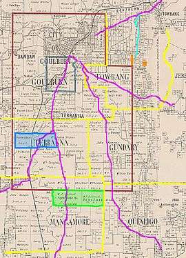 Location of Terranna in 1900 outlined in yellow | |
|
Terrana Parish | |
| Coordinates | 34°51′57″S 149°40′02″E / 34.86583°S 149.66722°ECoordinates: 34°51′57″S 149°40′02″E / 34.86583°S 149.66722°E |
| LGA(s) | Goulburn Mulwaree |
| County | Argyle |
| Division | Eastern |
The Parish of Terrana is a parish of Argyle County, New South Wales, Australia.[1][2]
The area is similar to the locality of Tirrannaville, which partly lies in the Goulburn Parish.
History
The area was first inhabited by the Gundungurra people,[3][4][5] and by the mid 1840s the NSW colonial government had granted numerous land grants in area, beginning white settlement. A Public School was established in 1869. The area is today predominantly used for agriculture though it lies in the Sydney-Canberra transit corridor.
References
- ↑ New South Wales Parish maps preservation project.
- ↑ Robert McLean, The New atlas of Australia : the complete work containing over one hundred maps and full descriptive geography of New South Wales, Victoria, Queensland, South Australia and Western Australia, together with numerous illustrations and copious indices (Sydney :J. Sands, [1886) Map 11.
- ↑ Dharag Neighbours.
- ↑ Encyclopaedia of Aboriginal Australia, Goulburn:Aborigines, Archive associated with Australia Street project(University of Technology, Sydney, 2006
- ↑ Norman Tindall, Gandangara (NSW) Aboriginal Tribes of Australia, (South Australian Museum, 2006).
This article is issued from
Wikipedia.
The text is licensed under Creative Commons - Attribution - Sharealike.
Additional terms may apply for the media files.