Terihi
 Map of Terihi | |
| Geography | |
|---|---|
| Location | South Pacific Ocean |
| Coordinates | 10°01′05″S 138°48′08″W / 10.01806°S 138.80222°WCoordinates: 10°01′05″S 138°48′08″W / 10.01806°S 138.80222°W |
| Archipelago | Marquesas Islands |
| Area | 0.15 km2 (0.058 sq mi) |
| Coastline | 3.40 km (2.113 mi) |
| Administration | |
|
France | |
| Overseas country | French Polynesia |
| Demographics | |
| Population | 0 |
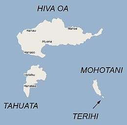
Terihi is a small, uninhabited, rocky island in the Marquesas Islands, less than 300 m (0.19 mi) southeast from Mohotani. It has an area of 0.15 square kilometres (0.06 square miles) and a coastline of 3.40 kilometres (2.11 miles).
In 1992, the island became officially protected by its inclusion in the Motane Nature Reserve.
See also
| Northern Marquesas: | |||
|---|---|---|---|
| Southern Marquesas: | |||
This article is issued from
Wikipedia.
The text is licensed under Creative Commons - Attribution - Sharealike.
Additional terms may apply for the media files.