Temósachic Municipality
| Temósachic | |
|---|---|
| Municipality | |
 Municipality of Temósachic in Chihuahua | |
|
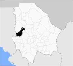
Temósachic Location in Mexico | |
| Coordinates: 28°57′N 107°50′W / 28.950°N 107.833°WCoordinates: 28°57′N 107°50′W / 28.950°N 107.833°W | |
| Country |
|
| State | Chihuahua |
| Municipal seat | Temósachic |
| Founded | November 21, 1844 |
| Area | |
| • Total | 5,361.9 km2 (2,070.2 sq mi) |
| Population (2010) | |
| • Total | 6,211 |
| • Density | 1.2/km2 (3.0/sq mi) |
Temósachic is one of the 67 municipalities of Chihuahua, in northern Mexico. The municipal seat lies at Temósachic. The municipality covers an area of 5,361.9 km².
As of 2010, the municipality had a total population of 6,211,[1] down from 6,319 as of 2005.[2]
As of 2010, the town of Temósachic had a population of 1,841.[1] Other than the town of Temósachic, the municipality had 329 localities, none of which had a population over 1,000.[1]
Geography
Towns and villages
The municipality has 421 localities. The largest are:
| Name | Population (2005) |
|---|---|
| Temósachic | 1,786 |
| Yepachic | 649 |
| Yepómera | 485 |
| Cocomorachic | 314 |
| Total Municipality | 6,319 |
References
- 1 2 3 "Temósachic". Catálogo de Localidades. Secretaría de Desarrollo Social (SEDESOL). Retrieved 23 April 2014.
- ↑ "Temósachic". Enciclopedia de los Municipios de México. Instituto Nacional para el Federalismo y el Desarrollo Municipal. Retrieved October 25, 2008.

This article is issued from
Wikipedia.
The text is licensed under Creative Commons - Attribution - Sharealike.
Additional terms may apply for the media files.