Greater Tehran
| Greater Tehran تهران بزرگ | |
|---|---|
| Metropolis | |
| کلانشهر تهران · Tehran Metropolis | |
|
[[File:|Azadi Tower|266px]] 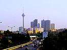 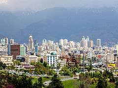 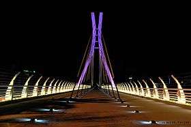  .JPG) 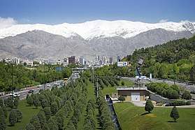  Clockwise from top: Azadi Tower, Shemiran, Ab o Atash Park, Mount Tochal seen from Modarres Expressway, Shams ol Emareh, Ferdows Garden, and Milad Tower seen from Parkway. | |
 | |
 Greater Tehran | |
| Coordinates: 35°41′46″N 51°25′23″E / 35.69611°N 51.42306°ECoordinates: 35°41′46″N 51°25′23″E / 35.69611°N 51.42306°E | |
| Country |
|
| Province | Tehran |
| Area[1] | |
| • Urban | 730 km2 (280 sq mi) |
| • Metro | 9,500 km2 (3,700 sq mi) |
| Elevation | 1,200 to 1,980 m (3,900 to 6,470 ft) |
| Population (2016)[2] | |
| • Density | 1,600/km2 (4,000/sq mi) |
| • Urban | 8,846,782 |
| • Metro | 15,000,000 |
| • Population Rank in Iran | 1st |
| Time zone | UTC+03:30 (IRST) |
| • Summer (DST) | UTC+04:30 (IRDT) |
| Area code(s) | 021 |
| Website | www.tehran.ir |
Greater Tehran is the urban agglomeration around Tehran that covers central part of Tehran Province and eastern part of Alborz Province. that covers the contiguous cities of Tehran, Ray, Shemiranat, and other areas.
As of 2012, Greater Tehran hosts a population of close to 14 million residents.[3] Data of 2016 census shows the population of 13.3m in Tehran Province (only ~0.2m of them are outside of Tehran and suburban counties) and 2.2m in [Karaj County] and [Fardis] combined. This allow to estimate that the population of Tehran agglomeration was about 15m people in 2016.
Greater Tehran as agglomeration should not be mixed with the following:
- Tehran Province (area 18814 km², population 13.27 m - 2016). Part of the province is too remoted from Tehran and has too low population density to be classified as the part of agglomeration
- Tehran County (area ~1300 km², population 8.85 m (2016) with ~97,5% of the population living in Tehran city itself)
- Tehran as the city. Includes 22 districts; two of them fully, and one partially are located outside of Tehran county. City area is about 730 km². The extension of the city to other counties began in 1973 to include the villages surrounding the city of Tajrish (Evin, Darakeh, Niyavaran, Rostan Abad, Gholhak, Zargandeh, Elahiyeh, Davoudiyeh, Zarrabkhaneh) and the cities of Vanak and Rey to which “Kooye Siman” had been annexed during the years 1956 to 1966.
Geography of Tehran Metropolis
There is no exact definition of Tehran agglomeration borders and composition. Beside Tehran County, also Shemiranat County, Rey County, Eslamshahr County, Pakdasht County, Robat-Karim County, Varamin County, Shahriar County, Qods County, Malard County, Pishva County and Baharestan County in Tehran Province and also Karaj County and probably even Nazarabad County and Savojbolagh County in Alborz Province can be regarded as parts of the agglomeration.
References
- ↑ Approximate estimate. Includes ~40% of Tehran Province area and ~2000 km2 of Alborz Province
- ↑ Urban population: Data for Tehran County. ~97.5% of county population live in Tehran city
Metro population: Estimate on base of census data, includes central part of Tehran province and Karaj County and Fardis from Alborz province - ↑ PopulationData.net – Iran
Tir
Abad
Jandarmeri
Bakhtari
Shemiran
Hosseyn
Abad
No
Ferdows
Sazman-e
Barnameh
Abad
Dastgah
Dastgah
Havayi
No
Chenar
Hassan
Morghi
Fallah
Abad
Niruz
Abad
Daru
Vali-Asr
Bari
Azari
Bokharaee
Abad
Abad
Aban
Qassab
Abad
Babaveyh
Abdol-Azim
Azadi
-Shahr
Haj-Seyf
Cheshmeh
Rah-Ahan