Whirinaki, Northland
| Whirinaki | |
|---|---|
 Whirinaki | |
| Coordinates: 35°28′26″S 173°27′45″E / 35.47389°S 173.46250°E | |
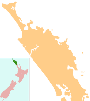
| Country | New Zealand |
| Region | Northland Region |
| District | Far North District |
| Population (c.2005) | |
| • Total | 200 |
Whirinaki is a locality in the south Hokianga, in Northland, New Zealand. The name means "to lean against a support".[1] Highway 12 runs through it. Opononi lies to the south west, and Rawene lies to the north east.[2][3]
The population is approximately 200 people, 90% of which are Māori. A large proportion of the population lives on papakāinga land.[4]
The area was raided by Te Roroa in 1810 or 1811, during the Musket Wars. All the inhabitants of Opara village were killed.[5]
Education
Te Kura Kaupapa Maori o Te Tonga o Hokianga is a coeducational full primary (years 1-8) school with a decile rating of 2 and a roll of 57.[6] It is a Kura Kaupapa Māori school which teaches fully in the Māori language.
There was a Whirinaki Native School during the early-mid 20th century.[7]
Coordinates: 35°28′26″S 173°27′45″E / 35.47389°S 173.46250°E
Notes
- ↑ "Ngā Puhi - Ancestors". Te Ara: The Encyclopedia of New Zealand.
- ↑ Peter Dowling (editor) (2004). Reed New Zealand Atlas. Reed Books. pp. map 6. ISBN 0-7900-0952-8.
- ↑ Roger Smith, GeographX (2005). The Geographic Atlas of New Zealand. Robbie Burton. pp. map 22. ISBN 1-877333-20-4.
- ↑ "Nga Mahi Hapai – Whirinaki Waterline" (.DOC). Office for the Community and Voluntary Sector. c. 2005.
- ↑ Smith, Stephenson Percy (1910). "Further Wars on the Border-Land". Maori Wars of the Nineteenth Century. p. 52.
- ↑ "Te Kete Ipurangi - Te Kura Kaupapa Maori o Te Tonga o Hokia". Ministry of Education.
- ↑ Lange, Raeburn (1999). May the People Live: a history of Maori health development, 1900-1920. p. 76. ISBN 1869402146.