Tap o' Noth
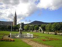 Tap o' Noth seen from Rhynie | |
 Tap o' Noth Shown within Aberdeen | |
| Coordinates | 57°21′05″N 2°51′31″W / 57.3514°N 2.8586°WCoordinates: 57°21′05″N 2°51′31″W / 57.3514°N 2.8586°W |
|---|---|
| Type | Hill fort |
The Tap o' Noth is a hill fort on top of the Hill of Noth, 20 miles west of Inverurie in Aberdeenshire, Scotland at grid reference NJ485293. It is the second highest fort in Scotland and its main feature is its well-preserved vitrified wall which encloses an area of approximately 100 m by 30 m. Archaeological finds from the site include a stone axe head dated to between c2000BC–c800BC, and a decorated bronze rein-ring dated to the 1st–3rd century AD.[1]
The site has been designated a scheduled ancient monument. [2]
See also

References
- ↑ "Marischal Virtual Museum - The University of Aberdeen". www.abdn.ac.uk. Retrieved 2008-02-09.
- ↑ "Tap o'Noth,fort - SM63". Historic Environment Scotland. Retrieved 15 September 2017.
- "Aberdeenshire Council - Tap O'Noth Promontory Fort". www.aberdeenshire.gov.uk. Retrieved 2008-02-09.
- "Tap O'Noth - National Monuments Record of Scotland". www.rcahms.gov.uk. Retrieved 2008-02-09.
This article is issued from
Wikipedia.
The text is licensed under Creative Commons - Attribution - Sharealike.
Additional terms may apply for the media files.