Taiarapu-Est
| Tai'arapu-Est | |
|---|---|
| Commune | |
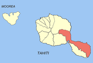 Location of the commune (in red) within the Windward Islands. The island of Meheti'a lies outside of the map. | |
| Coordinates: 17°42′12″S 149°20′00″W / 17.7033°S 149.3333°WCoordinates: 17°42′12″S 149°20′00″W / 17.7033°S 149.3333°W | |
| Country | France |
| Overseas collectivity | French Polynesia |
| Government | |
| • Mayor | Sylve Perry |
| Area | 218.3 km2 (84.3 sq mi) |
| Population (August 2007 census)1 | 11,549 |
| • Density | 53/km2 (140/sq mi) |
| INSEE/Postal code | 98747 /98719 |
| Elevation | 0–1,306 m (0–4,285 ft) |
| 1 Population without double counting: residents of multiple communes (e.g., students and military personnel) only counted once. | |
Ta'iarapu-Est (literally "Tai'arapu East") is a commune of French Polynesia, an overseas territory of France in the Pacific Ocean. The commune of Tai'arapu-Est is located on the island of Tahiti, in the administrative subdivision of the Windward Islands, themselves part of the Society Islands.
Overview
The commune extends over a part of Tahiti Nui ("big Tahiti") and half of the peninsula of Tahiti Iti ("small Tahiti", aka Tai'arapu). The commune also includes the uninhabited island of Mehetia (2.3 km²/0.9 sq. miles), located 112 kilometres (70 mi) east of Tahiti Iti.
Ta'iarapu-Est consists of the following associated communes:
The administrative centre of the commune is the settlement of Taravao, on the isthmus linking Tahiti Nui and Tahiti Iti.
See also
References
| Wikimedia Commons has media related to Taiarapu-Est. |
This article is issued from
Wikipedia.
The text is licensed under Creative Commons - Attribution - Sharealike.
Additional terms may apply for the media files.