Tabula Peutingeriana
Tabula Peutingeriana (Latin for "The Peutinger Map"), also referred to as Peutinger's Tabula[1] or Peutinger Table, is an illustrated itinerarium (ancient Roman road map) showing the layout of the cursus publicus, the road network of the Roman Empire.
The map is a 13th-century parchment copy of a possible Roman original. It covers Europe (without the Iberian Peninsula and the British Isles), North Africa, and parts of Asia, including the Middle East, Persia, and India. According to one hypothesis, the existing map is based on a document of the 4th or 5th century that contained a copy of the world map originally prepared by Agrippa during the reign of the emperor Augustus (27 BC – AD 14). However, Emily Albu has suggested that the existing map could instead be based on an original from the Carolingian period.[2]
Named after the 16th-century German antiquarian Konrad Peutinger, the map is now conserved at the Austrian National Library in Vienna.
Archetype
The Tabula is thought to be a distant descendant of the map prepared under the direction of Marcus Vipsanius Agrippa, a Roman general, architect, and friend of emperor Augustus. After Agrippa's death in 12 BC, that map was engraved in marble and put on display in the Porticus Vipsania in the Campus Agrippae area in Rome, close to the Ara Pacis building.
The early imperial dating for the archetype of the map is supported by American historian Glen Bowersock, and is based on numerous details of Roman Arabia that look entirely anachronistic for a 4th-century map.[3] Bowersock concluded that the original source is likely the map made by Vipsanius Agrippa.[4] This dating is also consistent with the map's inclusion of the Roman town of Pompeii near modern-day Naples, which was never rebuilt after it had been destroyed in an eruption of Mount Vesuvius in AD 79.
The original Roman map, of which this may be the only surviving copy, was last revised in the 4th or early 5th century.[5][6] It shows the city of Constantinople, founded in 328, and the prominence of Ravenna, seat of the Western Roman Empire from 402 to 476, which suggests a fifth-century revision according to Levi and Levi.[5] The presence of certain cities of Germania Inferior that were destroyed in the mid-fifth century also provides a terminus ante quem, i.e. the map's latest creation date, though Emily Albu suggests that this information could have been preserved in textual, not cartographic, form.
Map description
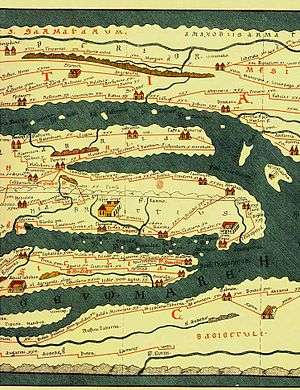
The Tabula Peutingeriana is thought to be the only known surviving map of the Roman cursus publicus, the state-run road network. The surviving map itself was created by a monk in Colmar in modern-day eastern France in 1265.[7] It is a parchment scroll, 0.34 metres (1 foot 1 inch) high and 6.75 metres (22.1 feet) long, assembled from eleven sections, a medieval reproduction of the original scroll.
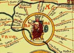
It is a very schematic map, designed to give a practical overview of the road network, as opposed to an accurate representation of geographic features: the land masses shown are distorted, especially in the east-west direction. The map shows many Roman settlements and the roads connecting them, as well as other features such as rivers, mountains, forests and seas. The distances between settlements are also given. In total no fewer than 555 cities and 3,500 other place names are shown on the map.[8] The three most important cities of the Roman Empire at the time – Rome, Constantinople and Antioch – are represented with special iconic decoration.
Besides the totality of the empire, the map also shows areas in the Near East, India and the Ganges, Sri Lanka (Insula Taprobane), and even an indication of China. It even shows a "Temple to Augustus" at Muziris on the modern-day Malabar Coast, one of the main ports for trade with the Roman Empire on the southwest coast of India.[9] On the western end of the scroll, the absence of Morocco, the Iberian Peninsula, and the British Isles indicates that a twelfth original section has been lost in the surviving copy; the missing section was reconstructed in 1898 by Konrad Miller.[10]
The map appears to be based on "itineraries", lists of destinations along Roman roads, as the distances between points along the routes are indicated.[11] Travelers would not have possessed anything so sophisticated as a modern map, but they needed to know what lay ahead of them on the road and how far. The Peutinger Table represents these roads as a series of stepped lines along which destinations have been marked in order of travel. The shape of the parchment pages accounts for the conventional rectangular layout. However, a rough similarity to the coordinates of Ptolemy's earth-mapping gives some writers hope that some terrestrial representation was intended by the unknown original compilers.
The stages and cities are represented by hundreds of functional place symbols, used with discrimination from the simplest icon of a building with two towers to the elaborate individualized "portraits" of the three great cities. The editors Annalina and Mario Levi concluded that the semi-schematic, semi-pictorial symbols reproduce Roman cartographic conventions of the itineraria picta described by 4th-century writer Vegetius,[12] of which this is the sole known testimony.
History
The map was discovered in a library in the city of Worms by German scholar Conrad Celtes in 1494, who was unable to publish his find before his death and bequeathed the map in 1508 to Konrad Peutinger, a German humanist and antiquarian in Augsburg, after whom the map is named.[7] The Peutinger family kept possession of the map for more than two hundred years until it was sold in 1714. It then bounced between several royal and elite families until it was purchased by Prince Eugene of Savoy for 100 ducats; upon his death in 1737, it was purchased for the Habsburg Imperial Court Library in Vienna (Hofbibliothek). It is today conserved at the Austrian National Library at the Hofburg palace in Vienna.[13]
In 2007, the map was placed on the UNESCO's Memory of the World Register, and in recognition of this, it was displayed to the public for a single day on 26 November 2007. Because of its fragile condition, it is not usually on public display.[14]
Printed editions
The map was copied for Dutch cartographer Abraham Ortelius and published shortly after his death in 1598. A partial first edition was printed at Antwerp in 1591 (titled Fragmenta tabulæ antiquæ) by Johannes Moretus, who would print the full Tabula in December 1598, also at Antwerp. Johannes Janssonius published another version in Amsterdam, c. 1652.
In 1753 Franz Christoph von Scheyb published a copy, and in 1872 Konrad Miller, a German professor, was allowed to copy the map. Several publishing houses in Europe then made copies. In 1892 publishers Williams and Norgate published a copy in London, and in 1911 a sheet was added showing the reconstructed sections of the British Isles and the Iberian peninsula missing in the original.[1]
Map

Notes
- 1 2 Ravenstein 1911, p. 637.
- ↑ Emily Albu, The Medieval Peutinger Map: Imperial Roman Revival in a German Empire. Cambridge; New York: Cambridge University Press, 2014
- ↑ Bowersock 1994, pp. 169–170,175,177,178–179,181,182,184.
- ↑ Bowersock 1994, p. 185.
- 1 2 Levi & Levi 1967, p.
- ↑ Bagrow 2010, p. 37
- 1 2 Nussli
- ↑ Lendering 2016
- ↑ Ball 2000, p. 123.
- ↑ Talbert 2010, p. 189
- ↑ Not all the stages are between towns: sometimes a crossroads marks the staging point.
- ↑ Vegetius' "...viarum qualitas, compendia, diverticula, montes, flumina ad fidem descripta suggest a more detailed "pictorial itinerary" than either the Antonine Itinerary or the Tabula Peutingeriana offers.
- ↑ Accession number: Codex 324.
- ↑ Bell 2007.
References
- Levi, Annalina; Levi, Mario (1967), Itineraria picta: Contributo allo studio della Tabula Peutingeriana (in Italian), Rome: Bretschneider — Includes the best easily available reproduction of the Tabula Peutingeriana, at 2:3 scale.
- Levi, Annalina; Levi, Mario (1978), La Tabula Peutingeriana (in Italian), Bologna: Edizioni Edison — Includes a reproduction of the Tabula Peutingeriana, at 1:1 scale.
- Ball, Warwick (2000), Rome in the East: The transformation of an empire, London and New York: Routledge, ISBN 0-415-11376-8
- Bagrow, Leo (2010), History of Cartography, Transaction Publishers, p. 37, ISBN 978-1-4128-2518-4
- Bell, Bethany (26 November 2007), Ancient Roman road map unveiled, BBC News
- Bowersock, Glen (1994), Roman Arabia, Harvard University Press, ISBN 0-674-77756-5
- Lendering, Jona (24 July 2016) [2003], "Peutinger Map", Livius, retrieved 27 December 2016
- Nussli, Christos, "The Tabula Peutingeriana, a Roman Road Map", Euratlas.net, retrieved 15 August 2016

- Talbert, Richard (2010), Rome's World: The Peutinger Map Reconsidered, Cambridge University Press, ISBN 9780521764803
External links
| Wikimedia Commons has media related to Tabula Peutingeriana. |
| Wikisource has the text of the 1905 New International Encyclopedia article Peutingerian Table. |
- Peutinger map as a seamless whole, in color, with overlaid layers, by Richard Talbert
- Omnes Viae: Tabula Peutingeriana as route planner, plotted on Google Maps
- Roman Sites: complete scan of Tabula Peutingeriana 13th-century
- Bibliotheca Augustana: complete scan of Tabula Peutingeriana 1887-1888
- Slide #120 Monograph:Tabula Peutingeriana, First century A.D., Cartographic Images
- Tabula Peutingeriana (high-resolution JPEGs & Alphabetical index) at Sorin Olteanu's LTDM Project (soltdm.com)
- Tabula Peutingeriana – Interactive Navigation and Index with Zoom
- Tabula Peutingeriana: real-size reproduction with permission of the National Austrian Library
- Seadragon Deep Zoom representation of the map