Töpfer (hill)
| Mount Töpfer | |
|---|---|
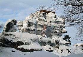 Rock formation with look-out on Mount Töpfer | |
| Highest point | |
| Elevation | 582 m (1,909 ft) DE-HN |
| Coordinates | 50°50′54″N 14°45′44″E / 50.84833°N 14.76222°ECoordinates: 50°50′54″N 14°45′44″E / 50.84833°N 14.76222°E |
| Geography | |
| Location | Saxony, Germany |
| Geology | |
| Mountain type | sandstone |
Mount Töpfer is a mountain with an elevation of 582 metres near the municipality of Oybin in the German state of Saxony. It is situated in the Zittau Mountains which are part of the Lusatian Mountains. It is known for it interesting rock formations near the top. Its name Töpfer (English: Potter) was probably derived from the peak that resembles two chalices.

The mountain hut Töpferbaude
Rock Formations and Sights
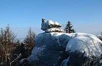
The Broody Hen (Brütende Henne) is one of many bizarre rock formations around the summit
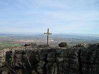
Summit cross with view towards the Izera Mountains
- Parrot (Papagei)
- Turtle (Schildkröte)
- Chick (Küken)
- Wobble Stone (Wackelstein)
- Broody Hen (Brütende Henne)
- European Summit Cross (Europakreuz)
- The Cave of Gratz (Gratzer Höhle)
This article is issued from
Wikipedia.
The text is licensed under Creative Commons - Attribution - Sharealike.
Additional terms may apply for the media files.