Tête de l'Estrop
| Tête de l'Estrop | |
|---|---|
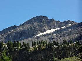 Tête de l'Estrop from the north | |
| Highest point | |
| Elevation | 2,961 m (9,715 ft) [1] |
| Prominence | 721 m (2,365 ft) [2] |
| Listing | Alpine mountains 2500-2999 m |
| Coordinates | 44°17′14″N 06°30′17″E / 44.28722°N 6.50472°ECoordinates: 44°17′14″N 06°30′17″E / 44.28722°N 6.50472°E |
| Geography | |
 Tête de l'Estrop Location in the Alps | |
| Location | Alpes-de-Haute-Provence, France |
| Parent range | Provence Alps and Prealps |
| Climbing | |
| Easiest route | from Foux d'Allos |
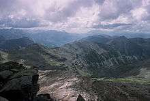
Tête de l'Estrop: view from the summit
The Tête de l'Estrop is a mountain of the French Prealps located in Alpes-de-Haute-Provence, France. It is the highest peak of the Provence Alps and Prealps.
Geography
Administratively the mountain is divided between the French communes of Prads-Haute-Bléone (southern slopes) and Méolans-Revel (vallon du Laverq, northern slopes).[1]
Access to the summit
The easiest route to the summit starts from La Foux d'Allos, a ski resort in the commune of Allos, which reaches the top through the eastern slopes of the mountain.
References
- 1 2 Géoportail IGN on www.geoportail.fr
- ↑ "Tête de l'Estrop - peakbagger". peakbagger.com. Retrieved 25 March 2015.
Maps
- French official cartography (Institut géographique national - IGN); on-line version: www.geoportail.fr
Bibliography
- Caracal et les Sancho Panza, Male Vesse, récit et 12 descentes de canyons dans le pays dignois, 2006 ( ISBN 2-9526064-0-4)
This article is issued from
Wikipedia.
The text is licensed under Creative Commons - Attribution - Sharealike.
Additional terms may apply for the media files.