Summers Glacier

Summers Glacier
Summers Glacier - Victory Mountains in Antarctica
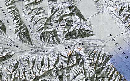
Excerpt from "Latino Peak", USGS Topographic map of the Cape Hallett area
Summers Glacier (72°13′S 167°28′E / 72.217°S 167.467°ECoordinates: 72°13′S 167°28′E / 72.217°S 167.467°E) is a tributary glacier that drains the vicinity west of Latino Peak and flows south to enter Pearl Harbor Glacier, in the Victory Mountains, Victoria Land. Mapped by United States Geological Survey (USGS) from surveys and U.S. Navy air photos, 1960-64. Named by Advisory Committee on Antarctic Names (US-ACAN) for James L. Summers, U.S. Navy, chief utilitiesman at McMurdo Station, 1967.
![]()
This article is issued from
Wikipedia.
The text is licensed under Creative Commons - Attribution - Sharealike.
Additional terms may apply for the media files.