Sula Valley
The Valley of Sula is the largest alluvial valley of Honduras. It is located in the northwest of the country, and within it lie several of Honduras's most important cities, such as San Pedro Sula, El Progreso, Choloma, Puerto Cortés, Villanueva, and Tela.
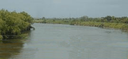
Hydrologically speaking, the area has two of the most important basins of Honduras: the basins of the Ulúa and Chamelecón rivers, leaving the area vulnerable to flooding, mainly in the rainy season.
The valley's ecosystem is mainly composed of tropical dry forests.
Economy
The valley's fertile soils have boosted its agricultural development.
Around 65% of the Gross domestic product of Honduras is generated in the valley, representing over 50% of the country's exports. Within it resides roughly 30% of the national population, due to the high concentration of the workforce, both in urban and rural communities.
Municipalities of the Sula Valley
| Municipality | Department | Population | Area |
|---|---|---|---|
| San Pedro Sula | Cortés | 913,857 | 840 km² |
| Choloma | Cortés | 250,505 | 458.6 km² |
| Puerto Cortés | Cortés | 85,000 | 400 km² |
| La Lima | Cortés | 80,000 | 117 km² |
| Omoa | Cortés | 42,000 | 382 km² |
| Pimienta | Cortés | 10,000 | 60 km² |
| Potrerillos | Cortés | 17,000 | 85 km² |
| San Antonio de Cortés | Cortés | 36,000 | 227 km² |
| San Francisco de Yojoa | Cortés | 23,000 | 96 km² |
| San Manuel | Cortés | 30,000 | 139 km² |
| Santa Cruz de Yojoa | Cortés | 67,000 | 725 km² |
| Villanueva | Cortés | 65,000 | 414 km² |
| El Progreso | Yoro | 310,000 | 548 km² |
| El Negrito | Yoro | 40,000 | 525 km² |
| Santa Rita | Yoro | 20,000 | 158 km² |
| Quimistán | Santa Bárbara | 38,000 | 742 km² |
| Petoa | Santa Bárbara | 12,000 | 213 km² |
| Tela | Atlántida | 102,273 | 1273 km² |
| Total | Valley of Sula | 2,033,365 | 7,384.6 km² |
See also
References
- "Contexto geográfico | ZMVS". www.zmvs.org (in Spanish). Retrieved 12 February 2017.
External links
- "Valle de Sula, Honduras - Geographical Names, map, geographic coordinates". www.geographic.org.