Thong Lo
Thong Lo (or Thong Lor, Thai: ทองหล่อ, pronounced [tʰɔːŋ lɔ̀ː]) also called Sukhumvit Soi 55, is a road and neighbourhood in Watthana district, Bangkok, Thailand. Thong Lor literally translates as "molten gold".[1] Its name comes from the name of a naval officer, Thonglo Khamhiran, one of the members of the Khana Ratsadon (people's party), the revolutionary group in 1932. He owned land and houses in this area in the past. Moreover, there are also many similarly named alleys of Sukhumvit Road, such as Soi Klang or Sukhumvit Soi 49 etc. Because in the pre-World War II, the land surrounding Sukhumvit Road along to Bang Na district, the contact area with Samut Prakan province, was considered a suburb Bangkok and like the rural area. Most were occupied by the navy.[2]
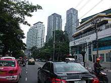
It runs from Sukhumvit Road, where the Thong Lo BTS Station is located, north to Phetchaburi Road. Originally housing car dealerships and "tacky" wedding showrooms, during the mid-2000s it became an increasingly trendy area.[3][4] A large Japanese expat community is located in the area, and many shops, restaurants and cocktails bars have opened,[5] with a large demand for new condominuims in the area.[6] In 2017 there was a crackdown on street food vendors operating on the street.[7]
Transportation
- Thong Lo BTS Station on the Sukhumvit Line of the Bangkok Skytrain is at the intersection with Sukhumvit Road.
- Khlong Saen Saep Express Boat – Thong Lo pier is at the bridge crossing Khlong Saen Saep, at the opposite end of the street, near New Phetchaburi Road intersection.
- The planned Grey Line (Bangkok Rapid Transit) would run along Thong Lo
References
- ↑ "Thonglor: Bangkok's golden mile". The BigChilli. Retrieved 2017-04-30.
- ↑ นายหนหวย (2012). ทหารเรือปฏิวัติ (in Thai). Bangkok: Matichon. ISBN 978-974-02-1025-2.
- ↑ Bangkok, Jason Gagliardi | (2005-08-01). "Bangkok's Chic Street". Time. ISSN 0040-781X. Retrieved 2017-04-30.
- ↑ "Thong Lo, Bangkok's hip new district". www.gluckman.com. Retrieved 2017-04-30.
- ↑ Kwak, Chaney. "Inside Bangkok's Booming Cocktail Scene". CNT. Retrieved 2017-04-30.
- ↑ "Bangkok's Thonglor in high demand from buyers and renters". Property Report. 2016-10-25. Retrieved 2017-04-30.
- ↑ "Day after law banning street food in Thong Lor takes effect, streets are a ghost town (PHOTOS) | Coconuts Bangkok". Coconuts. 2017-04-19. Retrieved 2017-04-30.
Coordinates: 13°43′57″N 100°34′56″E / 13.73248°N 100.58209°E