Stoyanov Cove

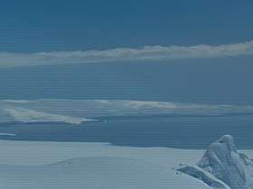

Stoyanov Cove (Bulgarian: Стоянов залив, ‘Stoyanov Zaliv’ \sto-'ya-nov 'za-liv\) is the 2.6 km wide cove indenting for 1.1 km the north coast of Livingston Island in the South Shetland Islands, Antarctica. Entered between Sandanski Point and Agüero Point on Ioannes Paulus II Peninsula. Most of the cove's coastline is formed by the terminus od Urdoviza Glacier.
The cove is named after the Bulgarian scientist Velichko Stoyanov (1932–1999) for his support for the Bulgarian Antarctic programme.
Location
Stoyanov Cove is located at 62°31′28″S 60°41′55″W / 62.52444°S 60.69861°WCoordinates: 62°31′28″S 60°41′55″W / 62.52444°S 60.69861°W. British mapping in 1968, Spanish in 1991, and Bulgarian in 2005 and 2009.
Maps
- L.L. Ivanov. Antarctica: Livingston Island and Greenwich, Robert, Snow and Smith Islands. Scale 1:120000 topographic map. Troyan: Manfred Wörner Foundation, 2010. ISBN 978-954-92032-9-5 (First edition 2009. ISBN 978-954-92032-6-4)
- Antarctic Digital Database (ADD). Scale 1:250000 topographic map of Antarctica. Scientific Committee on Antarctic Research (SCAR). Since 1993, regularly upgraded and updated.
- L.L. Ivanov. Antarctica: Livingston Island and Smith Island. Scale 1:100000 topographic map. Manfred Wörner Foundation, 2017. ISBN 978-619-90008-3-0
References
- Bulgarian Antarctic Gazetteer. Antarctic Place-names Commission. (details in Bulgarian, basic data in English)
- Stoyanov Cove. SCAR Composite Antarctic Gazetteer
This article includes information from the Antarctic Place-names Commission of Bulgaria which is used with permission.