Parish of Stewart
Map of the location of Stewart Parish in Far Western New South Wales.
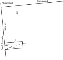
Stewart, is a remote civil parish of Poole County in far North West New South Wales.[1][2] Stewart is located 10 miles south of Cameron's Corner.
The Geography, of the parish is mostly the flat, arid landscape of the Channel Country. The parish has a Köppen climate classification of BWh (Hot desert)[3]. The County is barely inhabited with a population density of less than 1 person per 150km² and the landscape is a flat arid scrubland.
History
The parish is the traditional lands of the Wadigali people, one of the speakers of a Yarli language.
Charles Sturt explored the area in 1845.
See Also
- Stewart Parish, Killara County
References
- ↑ "Poole County". Geographical Names Register (GNR) of NSW. Geographical Names Board of New South Wales.
- ↑ / Map of the County of Poole : Western Division, .
- ↑ Peel, M. C.; Finlayson, B. L.; McMahon, T. A. (2007). "Updated world map of the Köppen–Geiger climate classification". Hydrol. Earth Syst. Sci. 11: 1633–1644. doi:10.5194/hess-11-1633-2007. ISSN 1027-5606. (direct: Final Revised Paper)
Coordinates: 29°29′37″S 141°08′05″E / 29.49361°S 141.13472°E
This article is issued from
Wikipedia.
The text is licensed under Creative Commons - Attribution - Sharealike.
Additional terms may apply for the media files.