Steinschartenkopf
| Steinschartenkopf | |
|---|---|
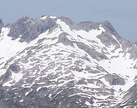 The Steinschartenkopf from the south between the Kleiner Steinscharte and Socktalscharte notches | |
| Highest point | |
| Elevation | 2,615 m (AA) (8,579 ft) |
| Prominence | 74 m ↓ Kleine Steinscharte |
| Isolation | 0.4 km → Hohes Licht |
| Coordinates | 47°17′06″N 10°16′51″E / 47.285°N 10.28083°ECoordinates: 47°17′06″N 10°16′51″E / 47.285°N 10.28083°E |
| Geography | |
| Parent range | Central main chain, Allgäu Alps |
| Climbing | |
| Normal route | along the Heilbronn Way |

The Steinschartenkopf is a rocky peak, 2,615 m, in the Hochlicht range in the Allgäu Alps. It is located between the Wilder Mann to the north and the Hohes Licht to the south and is the sixth highest summit in the Allgäu Alps. The popular Heilbronn Way (Heilbronner Weg) runs over the summit.
Ascent
The Steinschartenkopf is usually only climbed as part of a hike along the Heilbronn Way. As a destination in its own right it is of limited interest, but it is the highest point on the whole of the Heilbronn Way. From the direction of the Rappensee Hut the only ladder of the mountain path runs up to the summit. After a few metres further, a ladder bridge leads to the path in the directino of the Socktalscharte col.
Literature
- Dieter Seibert: Allgäuer Alpen Alpin, Alpine Club Guide. Munich, Bergverlag Rudolf Rother, 2004. ISBN 3-7633-1126-2
- Alpine Club map 1:25,000 series, Sheet 2/1, Allgäuer- Lechtaler Alpen, West
External links
| Wikimedia Commons has media related to Steinschartenkopf. |
This article is issued from
Wikipedia.
The text is licensed under Creative Commons - Attribution - Sharealike.
Additional terms may apply for the media files.