Stegny
| Stegny | |
|---|---|
| Warsaw Neighborhood | |
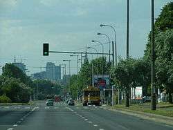 Sobieskiego Street in Stegny, Warsaw | |
| Coordinates: 52°10′40″N 21°02′53″E / 52.177642°N 21.047995°ECoordinates: 52°10′40″N 21°02′53″E / 52.177642°N 21.047995°E | |
| Country |
|
| Voivodeship | Masovian |
| County/City | Warsaw |
| Notable landmarks | Speed skating ring Stegny |
| Time zone | UTC+1 (CET) |
| • Summer (DST) | UTC+2 (CEST) |
| Area code(s) | +48 22 |
Stegny is a neighborhood in Mokotów district of Warsaw, Poland. It is a primarily residential, with several small retail centers and "convenience" shops including small grocery stores, butchers shops, bakeries, and the like. Stegny is characterized by its many concrete high-rise apartment buildings, constructed during the 1970s under Communist rule. These building are so alike in appearance that they have been painted various colors to allow local residents to tell them apart. Additionally, there are several apartment blocks of only five stories and many newer single-family townhouses that have been built since the 1990s.

Stegny area within Mokotów according to City Information System in Warsaw

Anthony Maria Zaccaria Church in Stegny
| Wikimedia Commons has media related to Stegny. |
Neighbourhoods of Mokotów | ||
|---|---|---|
 | ||
This article is issued from
Wikipedia.
The text is licensed under Creative Commons - Attribution - Sharealike.
Additional terms may apply for the media files.