Stecknadelhorn
| Stecknadelhorn | |
|---|---|
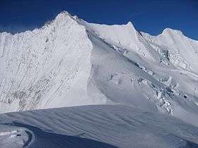 The Stecknadelhorn (right of centre) between the Nadelhorn (left) and the Hohberghorn (far right) | |
| Highest point | |
| Elevation | 4,241 m (13,914 ft) |
| Prominence | 23 m (75 ft) |
| Isolation | 0.5 kilometres (0.31 mi) |
| Parent peak | Nadelhorn |
| Coordinates | 46°06′41.5″N 7°51′34.8″E / 46.111528°N 7.859667°ECoordinates: 46°06′41.5″N 7°51′34.8″E / 46.111528°N 7.859667°E |
| Geography | |
 Stecknadelhorn Location in Switzerland | |
| Location | Switzerland |
| Parent range | Pennine Alps |
| Climbing | |
| First ascent | 8 August 1887 by Oscar Eckenstein and Matthias Zurbriggen |
| Easiest route | Basic snow climb |
The Stecknadelhorn (4,241 m) is a mountain in the Pennine Alps in Switzerland. It lies on the Nadelgrat, a high-level ridge running roughly north–south above the resort of Saas Fee to the east, and the Mattertal to the west.
It was first climbed by Oscar Eckenstein and Matthias Zurbriggen on 8 August 1887.
The Stecknadelhorn is part of the Mischabel range, which culminates at the Dom (4,545 m).
References
- Dumler, Helmut and Willi P. Burkhardt, The High Mountains of the Alps, London: Diadem, 1994
External links
- "Stecknadelhorn". SummitPost.org.
- "The Nadelgrat". SummitPost.org.
This article is issued from
Wikipedia.
The text is licensed under Creative Commons - Attribution - Sharealike.
Additional terms may apply for the media files.