Alabama State Route 147
| ||||
|---|---|---|---|---|
 | ||||
| Route information | ||||
| Maintained by ALDOT | ||||
| Major junctions | ||||
| South end |
| |||
|
| ||||
| North end |
| |||
| Location | ||||
| Counties | Lee County, Chambers County | |||
| Highway system | ||||
| ||||

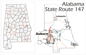
State Route 147 (SR 147) is a state highway maintained by the U.S. state of Alabama in the east-central part of Alabama. The highway acts as a connector between Interstate 85 (I-85) and U.S. Route 29 (US 29) in the southern part of Auburn and US 431 between Auburn and LaFayette.
SR 267 is a bypass of SR 147. The designation of SR 267 has been removed from the state highway system. SR 147 now follows that alignment.
SR 147 has been relocated along Shug Jordan Parkway by the Alabama Department of Transportation. The highway no longer follows South College Street into downtown Auburn. When Shug Jordan Pkwy ends at North College Street, the highway turns to follow along North College Street to the area of north Auburn known as The Bottle at US 280. Then, it follows its previous alignment through Gold Hill to its terminus at US 431 in Oak Bowery, north of Opelika.
Route description
SR 147 lies mostly within the city limits of Auburn. Approximately 1 mile (1.6 km) of the road travels through unincorporated Lee County, while 4.2 miles (6.8 km) lies in rural Chambers County.
SR 147 begins on College Street in Auburn and continues for 8.6 miles (13.8 km) until it shares one block with SR 14 in downtown Auburn. It continues along Birmingham Highway and US 280 (internally designated as SR 38) to mile 9.0, then continues on Heath Road in northern Auburn.
History
In 1939, the state of Alabama constructed the original segment of SR 147, connecting US 29 in downtown Auburn to what was then US 241 (now US 280) at The Bottle. In 1947, SR 147 was extended north 3 miles (4.8 km) to Gold Hill. The final extension from Gold Hill to US 431 to complete the northern portion of the highway did not occur until 1960. In 1998, the relocation of US 29 to I-85 led to the movement of the southern terminus of the highway from the intersection of Mitchum Avenue and College Street in downtown Auburn to a point 4 miles (6.4 km) south at the College Street interchange with I-85.
In 2006, the Alabama Department of Transportation began a relocation study for the southern half of SR 147. The study is to look at the possibility of rerouting the highway some 4 miles (6.4 km) west of Auburn, along the route of the proposed Auburn Outer Loop. The proposed relocation would begin at I-85 at the under-development Cox Road interchange (exit 50) and would travel north 13 miles (21 km) to connect with US 280 at mile marker 101.4, where it would join the current northern section of SR 147.
Major intersections
| County | Location | mi | km | Destinations | Notes |
|---|---|---|---|---|---|
| Lee | Auburn | 0.0 | 0.0 | Southern terminus; I-85 exit 51 | |
| 3.9– 4.0 | 6.3– 6.4 | ||||
| 8.6– 9.0 | 13.8– 14.5 | ||||
| Chambers | | 16.9 | 27.2 | Northern terminus | |
| 1.000 mi = 1.609 km; 1.000 km = 0.621 mi | |||||
See also


References
Route map: