Indiana State Road 7
| ||||
|---|---|---|---|---|
 | ||||
| Route information | ||||
| Maintained by INDOT | ||||
| Length | 36.549 mi[1] (58.820 km) | |||
| Major junctions | ||||
| South end |
| |||
|
| ||||
| North end |
| |||
| Location | ||||
| Counties | Jefferson, Jennings, Bartholomew | |||
| Highway system | ||||
| ||||

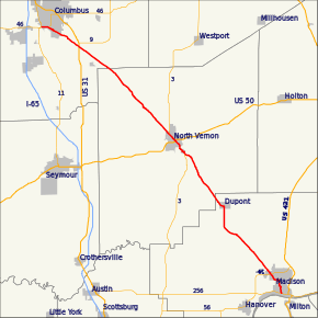
State Road 7 in the U.S. State of Indiana is located in southeast Indiana. It runs from northwest-to-southeast connecting the cities of Columbus and Madison.
History
Prior to 1926 the SR 7 designation was routed along the US 24 corridor. At this time modern SR 7 route was part of SR 26.[2] In 1926 the modern route of SR 7 was planned to become part of SR 11 designation.[3] Later in 1926 the SR 11 designation became SR 7, routed from Madison to Columbus.[4] Between 1931 and 1932 the entire route of SR 7 became a hard driving surface.[5][6] US 31 was rerouted onto SR 7 northwest of the modern intersection between the two roads between 1939 and 1941.[7][8] By 1942 US 31 was rerouted onto its modern route towards Columbus.[8][9] The northern end of SR 7 was moved to its current location, at SR 46, in either 1999 or 2000.[10][11]
Major intersections
| County | Location | mi[1] | km | Destinations | Notes |
|---|---|---|---|---|---|
| Jefferson | Madison | 0.000 | 0.000 | Southern terminus of SR 7 | |
| 3.049 | 4.907 | ||||
| Lancaster Township | 7.869 | 12.664 | Eastern terminus of SR 250 | ||
| Jennings | Vernon | 21.620 | 34.794 | Southern end of SR 3 concurrency | |
| North Vernon | 23.768 | 38.251 | |||
| 25.842 | 41.589 | Northern end of SR 3 concurrency | |||
| Bartholomew | Elizabethtown | 35.985 | 57.912 | ||
| 36.549 | 58.820 | Northern terminus of SR 7 | |||
1.000 mi = 1.609 km; 1.000 km = 0.621 mi
| |||||
References
- 1 2 Indiana Department of Transportation (July 2016). Reference Post Book (PDF). Indianapolis: Indiana Department of Transportation. Retrieved April 10, 2017.
- ↑ "Many State Highway Numbers Changed". The Hancock Democrat. Greenfield, IN. November 8, 1923. Retrieved June 2, 2017 – via Newspapers.com.

- ↑ "Road Numbers to Be Changed". The Hancock-Democrat. The Indianapolis News. September 30, 1926. Retrieved June 2, 2017 – via Newspapers.com.
- ↑ Indiana State Highway Commission (1926). State Highway System of Indiana (Map). Indianapolis: Indiana State Highway Commission. Retrieved June 2, 2017 – via Indiana State Library and Historical Bureau.
- ↑ Indiana State Highway Commission (September 30, 1931). State Highway System of Indiana (PDF) (Map). Indianapolis: Indiana State Highway Commission. Retrieved June 2, 2017 – via Indiana University Bloomington Libraries.
- ↑ Indiana State Highway Commission (January 1, 1932). State Highway System of Indiana (Map). 1:660,000. Indianapolis: Indiana State Highway Commission. OCLC 53092152. Retrieved June 2, 2017 – via Indiana State Library and Historical Bureau.
- ↑ Indiana State Highway Commission (1939). State Highway System of Indiana (Map). 1:633,600. Indiana State Highway Commission. OCLC 64016573. Retrieved June 2, 2017 – via Indiana State Library and Historical Bureau.
- 1 2 Indiana State Highway Commission (1941). State Highway System of Indiana (Map). 1:633,600. Indiana State Highway Commission. OCLC 64574634. Retrieved June 2, 2017 – via Indiana State Library and Historical Bureau.
- ↑ Indiana State Highway Commission (1942). State Highway System of Indiana (Map). 1:720,000. Indiana State Highway Commission. OCLC 64382867. Retrieved June 2, 2017 – via Indiana State Library and Historical Bureau.
- ↑ Indiana Department of Transportation (1999). Indiana Transportation Map (Map). 1:633,600. Indianapolis: Indiana Department of Transportation. OCLC 47737740.
- ↑ Indiana Department of Transportation (2000). Indiana Transportation Map (Map). 1:650,000. Indianapolis: Indiana Department of Transportation. OCLC 70269263.
External links
Route map: