St Patrick's Isle
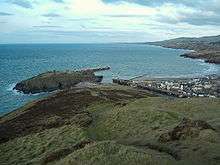
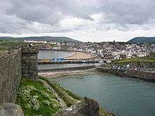
St Patrick's Isle (Manx: Ynnys Pherick) is a small tidal island on the west coast of the Isle of Man in the Irish Sea, largely occupied by Peel Castle and noted for its attractive and relatively well preserved historic castle ruins.
History
Archeological studies have shown permanent occupation on St Patrick's Isle dating to the Late Bronze Age. [1] The ruins on St Patrick's Isle include St Patrick's Church and an Irish-style round tower, St German's Cathedral, and the more recent residence of Lords of Mann. The ancient cathedral was left to decay in the 18th century, never to be rebuilt. The island's steep and rocky edges made it an ideal defensive outpost. It is said to be the place where St Patrick first set foot in the Isle of Man in 444 while returning from Liverpool to Ireland. Having established Christianity, he then appointed Germanus bishop, to oversee further development of the Church.[2] However, there is debate as to whether the name "St Patrick's Isle" pre-dates the thirteenth century.[1]
The islet is now a tourist site with the castle walls running close to the shoreline. There is a public walk around the outside of the castle, which lines the coastal edge of the islet. It is connected to the town of Peel on the Isle of Man by a causeway over Fenella Beach, named after the character in Sir Walter Scott's Peveril of the Peak. In addition to the historic ruins, the island is partially a sealife sanctuary.
St. Patrick's Isle was originally referred to as Inis (or Ynnys) Patraic in Manx.
References
- 1 2 Maddrell, Avril. "Mapping Changes Shades of Grief and Consolation in the Historic Landscape of St. Patrick's Isle, Isle of Man", Emotion, Place and Culture, (Laura Cameron, Mick Smith, Liz Bondi, Joyce Davidson, eds.), Ashgate Publishing, Ltd., 2012 ISBN 9781409488040
- ↑ Woolley, Sue. "Celebration of 'miracle man' St Patrick", IOM Today, 17 March 2009
External links
- Manx Place Names 1925 - Parish of Kirk Patrick
- Isle-of-Man.com Peel Castle & St Patrick's Isle with aerial photo
Coordinates: 54°13′33″N 4°42′06″W / 54.22583°N 4.70167°W