St Michael's Isle
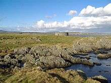
St Michael's Isle (Manx: Ellan Noo Mael or Ynnys Vaayl), popularly referred to as Fort Island, is an island in Malew parish in the Isle of Man, noted for its attractive ruins. It covers an area of 5.14 hectares (12.70 acres),[1] is about 400 metres (440 yards) long[2] from west to east, and is connected to the Langness Peninsula, near Derbyhaven, by a narrow causeway. The island itself is made of rocky slate and the soil is very acidic.[1] Nevertheless, it has important communities of maritime plants.[3]
There is evidence for human activity on the island from the Mesolithic period onwards[3] and there are two ancient buildings on the island. Both are in a state of ruin and closed to the public, though there are a number of walks which allow visitors to explore the surroundings.
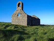
St Michael's Chapel, a 12th-century chapel, is on the south side of the island. This Celtic-Norse chapel was built on the site of an older Celtic keeill.
The island is the site of two great battles for the control of the Isle of Man in 1250 and 1275, when England, Scotland and the Manx were fighting for control of the island. The Manx won the first battle, but 25 years later they lost control to Scotland.[1]
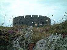
Derby Fort, a 17th-century fort, is at the eastern end of the island. It was built by James Stanley, the 7th Earl of Derby and Lord of Mann in 1645, during the English Civil War, to protect the then busy port of Derbyhaven.
The island is a bird sanctuary.
References
External links
- www.isleofman.com - Information about Fort Island
- St Michael's Isle
- Jon Wornham's galleries include photographs of Fort Island at
- http://www.island-images.co.uk/Year2001/0106070834.html - Derby Fort 7 Jun 2001
- http://www.island-images.co.uk/Year2003/0311060830.html - Chapel and Fort 6 Nov 2003
Coordinates: 54°04′26″N 4°36′27″W / 54.07389°N 4.60750°W