St Clement's Church, Oxford
| St Clement's | |
|---|---|
| St Clement's Parish Church | |
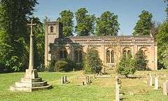 The present church, completed in 1828, viewed from the east | |
| Location | Marston Road, Oxford OX4 1BG |
| Country | England |
| Denomination | Church of England |
| Churchmanship | Evangelical |
| Website |
www |
| Architecture | |
| Architect(s) | Daniel Robertson |
| Style | Norman Revival |
| Years built | 1827–1828 |
| Administration | |
| Deanery | Cowley |
| Archdeaconry | Oxford |
| Diocese | Diocese of Oxford |
| Province | Province of Canterbury |
| Clergy | |
| Rector | Revd Rachel Gibson |
St Clement's Church is an evangelical Church of England parish church east of central Oxford, England.
History
The parish of St Clement's, Oxford was outside the city of Oxford until boundary changes in 1835. It was originally sited where the roads into Oxford from the east meet to cross Magdalen Bridge into the centre of Oxford.[1] In 1004 AD, the manor was granted to St Frideswide's Church (now Christ Church Cathedral, Oxford). In 1122 King Henry I gave the royal chapel of St Clement to the priory.
The original church building was demolished in 1829.[1] Its site became the open space called The Plain, which is now a roundabout. A new church was built on a new site during 1827–28 near the other end of St Clement's, at the southern end of Marston Road.[2] The architect Daniel Robertson designed the new building in a Norman style: a very early example of the revival of this style of 11th and early 12th century architecture. It was built by John Hudson of Oxford and cost £6,032 19s. 5d, supported by a gift of land from Sir Joseph Lock [3] and public subscriptions principally collected by John Henry Newman.[1] The building is above average size for a church but its design did not meet universal approval and was locally nicknamed the 'boiled rabbit'.[4]
See also
References
- 1 2 3 St Clement's Church, Oxford: Some History, UK.
- ↑ Old Oxford: East Oxford: The Plain.
- ↑ Diocese of Oxford Faculty & Consecration Register 1827-1844
- ↑ Mikhail, EH (ed) (1979). Oscar Wilde: Interviews and Recollections. London: Macmillan Press. p. 7. ISBN 9781349039258.
Sources
- Sherwood, Jennifer; Pevsner, Nikolaus (1974). Oxfordshire. The Buildings of England. Harmondsworth: Penguin Books. p. 291. ISBN 0-14-071045-0.
External links
- St Clement's Church, Oxford group on Facebook
- St Clement's Church (Oxford) information from Wikimapia
Coordinates: 51°45′12″N 1°14′16″W / 51.753233°N 1.237856°W