St. Martin's Le Grand
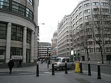
St. Martin's Le Grand was a former parish and liberty within the City of London, and is the name of a one-way street north of Newgate Street and Cheapside and south of Aldersgate Street. It forms the southernmost section of the A1 road.
Collegiate church
To the east of the road once stood the collegiate church and monastic precinct of St Martin's, of ancient origin. The precinct was within the City, but was not subject to its jurisdiction, constituting a liberty with the privilege of sanctuary.[2]
According to a somewhat dubious tradition, the church dated to the 7th or 8th century and was founded by King Wihtred of Kent.[3][4] It was, more certainly, rebuilt or founded about 1056 by two brothers, Ingelric and Girard, during the reign of Edward the Confessor. Its foundation was confirmed by a charter of William the Conqueror, dating to 1068.[2] The church was responsible for the sounding of the curfew bell in the evenings, which announced the closing of the City's gates. It was dissolved by King Henry VIII and demolished in 1548. It retained certain rights of sanctuary until 1697 and, as such, was a notorious haven for malefactors. One who sought sanctuary here was Miles Forrest, one of the reputed murderers of the Princes in the Tower.[2][5]
French Protestant Chapel
A French Protestant Chapel stood on the west side on the corner with Bull and Mouth Street from 1842 until 1888 when it was demolished to make way for new post office buildings.
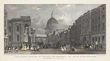
General Post Office
The General Post Office established its headquarters on the site of the monastic precinct in 1829. From here mail coaches departed for destinations across the country. Coaches bound for the north went up St Martin's Le Grand through Aldersgate – the first section of the Great North Road (now the A1 route) to York and Edinburgh.[6] It replaced the previous starting point at Hicks Hall in Smithfield Market. The Post Office building, a Neoclassical design by Robert Smirke, was demolished in 1911 and replaced by new premises immediately to the west, on the former site of Christ's Hospital school.[7]
Wireless development
Guglielmo Marconi (b. Bologna 1874, d. 1937) and assistant George Kemp successfully demonstrated the wireless telegraphy system between two Post Office buildings on 27 July 1896. A transmitter was placed on the roof of the Central Telegraph Office (located on Newgate Street) and a receiver on the roof of the General Post Office South (Carter Lane). The distance between the two buildings was 300 metres. Later that year the Post Office provided funding for Marconi to conduct further experiments on Salisbury Plain.[8] A plaque now appears at the BT Centre site; no such marker on the building that replaced the GPO South in the early years of the 21st Century.[9]
Transport links
The nearest London Underground station is St. Paul's, at the southern end of the street.
References
- ↑ The Post Office, St. Paul's Cathedral, and Bull & Mouth Inn, London in 1829. Government Art Collection. Retrieved 1 February 2018.
- 1 2 3 Ben Weinreb and Christopher Hibbert (1983) The London Encyclopedia: 735
- ↑ Walter Besant (1906) Medieval London, Vol II: 234
- ↑ History of London (1878) by Walter Thornbury
- ↑ Dictionary of City of London Street Names ISBN 0-7153-4880-9
- ↑ Norman Webster (1974) The Great North Road: 17
- ↑ Davies, Philip (2009). Lost London 1870–1945. Croxley Green: Transatlantic Press. p. 86. ISBN 978-0-9557949-8-8.
- ↑ postalheritage (2009-07-20). "Guglielmo Marconi and the Post Office". The British Postal Museum & Archive. Retrieved 2016-11-12.
- ↑ "GPO West Index". www.lightstraw.co.uk. Retrieved 2016-11-12.
External links
| Wikimedia Commons has media related to French Protestant Church in the City of London. |
| Wikimedia Commons has media related to St. Martin's Le Grand. |