St Boniface Down
| St Boniface Down | |
|---|---|
 | |
| Highest point | |
| Elevation | 241 m (791 ft) |
| Prominence | 241 m (791 ft) (island highpoint) |
| Listing | Marilyn, Hardy, County Top |
| Coordinates | 50°36′12.46″N 1°11′55.43″W / 50.6034611°N 1.1987306°WCoordinates: 50°36′12.46″N 1°11′55.43″W / 50.6034611°N 1.1987306°W |
| Geography | |
 St Boniface Down Location of St Boniface Down in the Isle of Wight | |
| Location | Isle of Wight, England |
| OS grid | SZ568785 |
| Topo map | OS Landranger 196 |
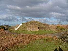
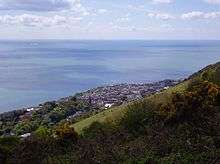
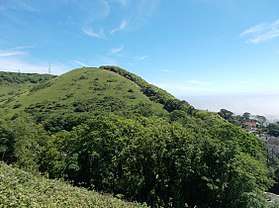
St Boniface Down is a chalk down on the Isle of Wight, England. It is located close to the town of Ventnor, in the southeast of the Island, and rises to 241 metres (791 ft), the Island's highest point, 1 kilometre (0.6 mi) north of the town.[1] There is reputed to be a wishing well on its southern slope, which requires the wisher to climb up from the south without looking back. In 1545 a French invasion force attempted this against a force of the Isle of Wight Militia commanded by Sir John Fyssher- which allegedly included several women archers- and were routed. In 1940 the radar station was bombed by Ju-87 Stuka dive bombers, which is reconstructed in the film "The Battle of Britain". The top is surmounted by a round barrow.
At the eastern foot of the down, on the A3055 road between Bonchurch and Luccombe, a path descends into Bonchurch Landslips via a scenic rock cleft, the Devil's Chimney.
Wildlife
St Boniface Down is home to the largest cricket within the British Isles, the great green bush cricket.
The area includes some unusual plant communities including acid grassland and heathland, resulting in parts of the Down being designated as a Site of Special Scientific Interest. The gravel capping supports extensive tracts of gorse Ulex europaeus with intervening areas of heathland and acid grassland dominated by heather Calluna vulgaris, bell heather Erica cinerea, purple moor-grass Molinia caerulea, bristle bent Agrostis curtisii and locally bilberry Vaccinium myrtillus. The occurrence of heathland on deep gravel overlying chalk, the naturalised holm oak woodland and the juxtaposition of heath and chalkland vegetation are all unusual biological features in Britain.[2]
Cultural references
St Boniface Down is also the name and was the inspiration of a 1956 work by the English composer, Trevor Duncan.
References
- ↑ "St Boniface Down, England". Peakbagger.com. Retrieved 2009-01-11.
- ↑ Natural England citation sheet for Ventnor Downs SSSI
50°36′12″N 1°11′55″W / 50.60346°N 1.19873°W