Środa Śląska
| Środa Śląska | |||
|---|---|---|---|
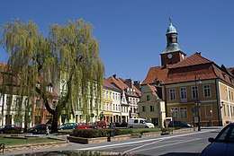 Historical town hall near the marketplace | |||
| |||
 Środa Śląska | |||
| Coordinates: 51°9′N 16°35′E / 51.150°N 16.583°E | |||
| Country |
| ||
| Voivodeship | Lower Silesian | ||
| County | Środa Śląska County | ||
| Gmina | Gmina Środa Śląska | ||
| Government | |||
| • Mayor | Bogusław Krasucki | ||
| Area | |||
| • Total | 14.94 km2 (5.77 sq mi) | ||
| Elevation | 130 m (430 ft) | ||
| Population (2006) | |||
| • Total | 8,800 | ||
| • Density | 590/km2 (1,500/sq mi) | ||
| Time zone | UTC+1 (CET) | ||
| • Summer (DST) | UTC+2 (CEST) | ||
| Postal code | 55-300 | ||
| Car plates | DSR | ||
| Website | http://www.srodaslaska.pl | ||

Środa Śląska [ˈɕrɔda ˈɕlɔ̃ska] (German: Neumarkt in Schlesien) is a town in Lower Silesian Voivodeship, in south-western Poland. It is the seat of Środa Śląska County, and of the smaller administrative district (gmina) called Gmina Środa Śląska. The town lies approximately 32 kilometres (20 mi) west of the regional capital Wrocław, on the Średzka Woda creek. As at 2006, the town has a population of 8,800.
History
Środa Śląska is situated in the central part of the Lower Silesia region at the main transport routes joining the east and west of Europe. Transforming it from a small commercial settlement into a center of urban character was carried out by a Polish prince Henryk the Bearded (1202-1238) whose idea was to enhance the economic and political significance of the Silesia region as a means to unify the Polish Kingdom. At around 1235 he granted the settlement a special law, based on the Magdeburg law, but adopted to the local conditions (średzkie law). It was a model on which many other Polish towns were later funded (including Opole, Kalisz, Wieliczka, Radom).
In 1428-31 the town was devastated by the Hussites (especially devastating was the attack in 1428 when Hussites robbed the town and burnt down the monastery and church of Franciscan order). In 1526 it was incorporated by the Habsburg monarchy. In 1740 the Prussian soldiers seized the town and incorporated it in the Prussian Kingdom. In 1806 it was sacked by French troops, and in 1813 by German soldiers. On February 9, 1945 the German troops withdrew from the town and it became again part of Poland.
For more information about the history of the region, see Silesia.
Personalities
- Laurentius Corvinus (1465–1527), scholar
- Franz Josef Kallmann
- Hugo von Kirchbach (1809 - 1887), Prussian general
- Leszek Kosedowski
See also
External links
- Municipal website
- Jewish Community in Środa Śląska on Virtual Shtetl
| Town and seat |  | |
|---|---|---|
| Villages | ||
Seat: Środa Śląska | ||
| Urban-rural gmina | _COA.svg.png) | |
| Rural gminas | ||