Sorrento Peninsula
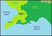
Map of the Sorrentine Peninsula
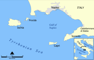
Map of the Gulf of Naples
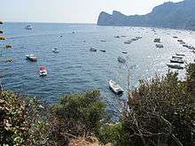
View of the peninsula near Massa Lubrense
The Sorrento Peninsula or Sorrentine Peninsula is a peninsula located in southern Italy that separates the Gulf of Naples to the north from the Gulf of Salerno to the south.
Geography
Overview
The peninsula is named after its main town, Sorrento, which is located on the north (Gulf of Naples) coast. The Amalfi Coast is located on the southern side. The Lattari Mountains form the geographical backbone of the peninsula. The island of Capri lies off the western tip of the peninsula in the Tyrrhenian Sea. The whole area is an important tourist destination.[1]
Municipalities
The peninsula lies on the territory of the province of Naples with 9 comunes and the province of Salerno with 12 comunes.
|
Transportation
Airports
![]()
- Naples International (NAP)
- Salerno Costa d'Amalfi (QSR)
See also
References
- ↑ "day trips from sorrento". Tuesday, 17 January 2017
External links
![]()
| Provinces |  | |
|---|---|---|
| Places |
| |
| History | ||
| Politics and government | ||
Categories | ||
This article is issued from
Wikipedia.
The text is licensed under Creative Commons - Attribution - Sharealike.
Additional terms may apply for the media files.