Solomon's Pools
Solomon's Pools (Arabic: برك سليمان, Burak Suleīmān, Solomon's Pools, or simply el-Burak, the pools; Hebrew: בריכות שלמה, Breichot Shlomo) are three ancient reservoirs located in the south-central West Bank, immediately to the south of the Palestinian village of al-Khader, about 5 kilometres (3.1 mi) southwest of Bethlehem and near the road to Hebron.[1]
Description
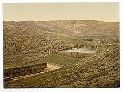
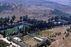
The three large reservoirs, following each other in line, stand several dozen meters apart, each pool with a roughly 6 metres (20 ft) drop to the next. They are rectangular or trapezoidal in shape, partly hewn into the bedrock and partly built, between 118 and 179 metres (387–587 ft) long and 8 to 16 metres (26–52 ft) deep, with a total capacity of well over a quarter of a million cubic metres (some 290,000 m³ or 75 million US gallons).[2]
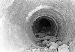
The pools were part of a complex ancient water system, initially built between sometime around 100 BC and ca. 30 AD. At its high point the system was providing water to the city and Jewish Temple of Jerusalem, as well as to the desert fortress and town of Herodium. At that time the pools were fed by two aqueducts, by several springs of the surrounding countryside including one situated underneath the lower pool, as well as by rainwater that descended from the overlooking hills. The pools acted as a storage and distribution facility, with the two feeder aqueducts bringing water to the pools from hills to the south. The collected water was then distributed by two other aqueducts leading from the pools northwards to Jerusalem, plus another one heading eastwards to the Herodium. Traces of all five initial aqueducts have been found.[2]
Below the middle pool are the remains of the British pump station that took the water by pipe to the Old City of Jerusalem. Another, more recent pumping station below the lower pool is still providing water to the town of Bethlehem.[2]
Near the Upper Pool stands a small Turkish fort, known either as Qal'at el-Burak (the "castle of the pools"), or as Qal'at Murad (the "castle of [Sultan] Murad"). The rectangular structure with four square corner towers was built by the Ottoman sultan Osman II in 1618.[3] It served as barracks for the Turkish soldiers guarding the Pools of Solomon and the commercial caravans between Jerusalem and Hebron, as well as a staging post on the local hajj route to Mecca. For a long time it was also used as a caravanserai or khan. After being allowed to decay since the middle of the 19th century, the ruined fortress has been largely rebuilt and developed as part of a new tourist complex.[3][4][5]
Name
The pools are named after the biblical King Solomon (around 950 BC), connecting them with the story described in the Book of Ecclesiastes 2.6: "I made myself pools from which to water the forest of growing trees." Josephus added to the story, writing that Solomon used to enjoy the beauty of the water-rich "Etham" (one of the main springs here is called Ein Eitam = Hebrew: עין עיטם ),[6][7] and the legend has it that the wise king built the pools for his wives, reportedly one thousand in number, so that they could bathe in their waters. French explorer Victor Guérin who visited the site in the late 19th-century described in great detail the source of the pools and their surrounding villages in a work published by him, entitled Description de la Palestine.[8]
History
The growing water needs of the Jerusalem Temple and the pilgrims it attracted during the later part of the Second Temple period, led to efforts to create a conduit able to reach the relatively high top of the Temple Mount by gravity alone. The hills south of Jerusalem are higher than the city and its Temple Mount, and contain a number of perennial springs, offering a good choice to the ancient engineers. The water system gradually created consisted of two aqueducts feeding the pools, which themselves acted as a collection and distribution facility, and of three further aqueducts carrying the water north to Jerusalem (two) and to Herodium (the third one). Together, the five aqueducts totalled some 80 kilometres in length.[2]
Recent evidence suggests that the lower pool was probably constructed during the Hasmonean period, between mid-second and mid-first century BC. It is connected to the so-called Lower or Low Level Aqueduct, built at the same time, which carries the water over a distance of 21.5 km to the Temple Mount in Jerusalem.[2]
A second phase occurred when Herod the Great, using Roman engineering and in connection with his rebuilding program of the Second Temple, created the sophisticated Wadi el-Byiar Aqueduct, which fed the upper pool. The aqueduct was partially built as a tunnel which collected underground water from the aquifer it was passing through, in the way of a qanat, to supplement the spring water and surface runoff it was also carrying. Water from the same upper pool was taken to Jerusalem's Upper City, where Herod had erected his new palace, through the king's ambitious so-called Upper or High Level Aqueduct. North of Bethlehem a tall bridge consisting of two levels of arches helped pass a deep valley.[2]
In a third phase, Roman prefect Pontius Pilate built 39 kilometres (24 mi) of aqueduct bringing yet more water to Solomon's Pools from the large collection pools at Arrub to the south.[9]
The water system based on Solomon's Pools has provided water to Jerusalem, on and off, for two millennia, all until 1967. The Low Level Aqueduct was the longest serving of the Jerusalem-bound ones. It started at the lower pool and once it reached Jerusalem, it crossed the Tyropoeon Valley over a bridge to find its way onto the Temple Mount platform, where it ended inside the great cisterns hidden underneath its surface.[2]
Major repairs to the water system were done by the 10th Roman Legion, Legio Fretensis during the second century CE, later by the Mamluks, the Ottomans and the British. In 1902 for instance, a new 16 km pipeline to Jerusalem was inaugurated to mark the 60th birthday of the Ottoman sultan Abdul Hamid II[2][10]
Springs feeding the pools
The pools are directly fed by four different springs: the most prominent is 'Ain Saleh, at the head of the Wadi Urtas (Artas), about 200 metres (660 ft) to the north-west of the upper pool.[11][12] The spring water is transferred to the upper pool by a large subterranean passage.[13] From the same direction comes the water of 'Ain Burak. 'Ain Attan or Ein Eitam is located south-east of the lower pool, while 'Ain Farujeh is right underneath that pool.[2]
Present day
Today the water from the pools reaches only to Bethlehem. The aqueduct beyond this has been destroyed once taken out of use in 1967.[2]
The three pools are surrounded by pine trees. The area around them has provided a pleasant atmosphere for picnics and relaxation over the centuries. On the north side, at the entry to the park, the Ottoman fort has been developed as part of a new tourist complex, housing among other things a museum of ethnography and history, and a restaurant with a garden area. The larger complex is planned to include the entire area around the three pools, including a conference center, recreational spaces, a mosque and more. As of December 2014, much of the complex is still being developed.[5]
While development is painfully needed in the area, there are concerns about the preservation of this remarkable archaeological and historical site.
Solomon's Pools have been managed since 2009 by the Convention Palace Company (CPC) CPC Link that operates/manages and preserves the following areas and surrounding:
- Solomon’s Pools: the archaeological site of three historical pools, two of them from the Roman period and the third from the Ottoman period
- Murad Castle: a 3500sqm Ottoman fort built for the protection of the pools
- Natural heritage forest
- The Convention Palace with 12 venues and a theatre
- Handicraft Center: a 12000sqm traditional bazaar
See also
References
- ↑ "About Solomons Pools". Mapcarta. Retrieved 22 December 2014.
- 1 2 3 4 5 6 7 8 9 10 "Solomon's Pools and relating aqueducts, the heart of Jerusalem's past water supply". HYDRIA Project. 2009. Retrieved 2014-12-18.
- 1 2 "Solomon's Pools". Museum With No Frontiers. Retrieved 22 December 2014.
- ↑ Mahmoud Hawari; Hamish Auld; Julian Hudson (1 January 2000). "Qal'at al-Burak. A Fort of the Ottoman Period South of Bethlehem". Levant: The Journal of the Council for British Research in the Levant. 32 (1): 101–120. doi:10.1179/lev.2000.32.1.101. Retrieved 22 December 2014.
- 1 2 "Solomon's Poolsi". Solomon's Pools/Kani Mani. Retrieved 22 December 2014.
- ↑ Flavius, Josephus Antiquities 8:186 (Book viii, chapter vii, section 3)
- ↑ Burial Places of the Fathers, published by Yehuda Levi Nahum in book: Ṣohar la-ḥasifat ginzei teiman (Heb. צהר לחשיפת גנזי תימן), Tel-Aviv 1986, p. 253, who quotes from an ancient rabbinic source: "Between Beth-Lehem and Hebron is the great pool, being the [water] duct that Hezekiah made, and the pool that he made, and it is [known as] Ein Etam." Rashi, who had not seen Josephus' writings, surmised that Ein Etam was the place known as "the waters of Nephtoah" (cf. Rashi's commentary on Yoma 31a and Zevahim 54b, s.v. עין עיטם); see also Rashi's comments on Joshua 15:8 and Deuteronomy 33.
- ↑ Victor Guérin, Description de la Palestine, Judée, Description de la Judée, Paris 1869, pp. 104–119, 303–309; See: Guérin, Victor (1869). Description Géographique Historique et Archéologique de la Palestine (in French). 1: Judee, pt. 3. Paris: L'Imprimerie Nationale.
- ↑ Murphy-O'Connor, Jerome (2008) The Holy Land: An Oxford Archaeological Guide from Earliest Times to 1700 Oxford University Press US, ISBN 0-19-923666-6 p 483
- ↑ Bussow, 2011, pp. 497, 536
- ↑ List of Geographical Names, (A Memo of the National Committee to the Government of the Land of Israel on the Method of Spelling Transliterated Geographical and Personal Names, plus Two Lists of Geographical Names), Lĕšonénu: A Journal for the Study of the Hebrew Language and Cognate Subjects, Benjamin Maisler, Tel-Aviv 1932, p. 21 (note 1): "The spring of Etam is [called] Ein Etam, but Etam is the ruin of Wadi Khukh, near Artas (Urtas)."
- ↑ See p. 21 (note 1) in: Maisler, Benjamin (1932). "A Memo of the National Committee to the Government of the Land of Israel on the Method of Spelling Transliterated Geographical and Personal Names, plus Two Lists of Geographical Names". Lĕšonénu: A Journal for the Study of the Hebrew Language and Cognate Subjects. 4 (3): 1–92. JSTOR 24384308. (Hebrew)
- ↑ Bromiley Geoffrey W (1995). The International Standard Bible Encyclopedia: E-J Wm. B. Eerdmans Publishing, ISBN 0-8028-3782-4 p 1025
Bibliography
- Bromiley Geoffrey W (1995). The International Standard Bible Encyclopedia: E-J Wm. B. Eerdmans Publishing, ISBN 0-8028-3782-4
- Bussow, Johann (2011). Hamidian Palestine: Politics and Society in the District of Jerusalem 1872-1908. BRILL. ISBN 9004205691.
- Flavius, Josephus Antiquities
- Murphy-O'Connor, Jerome (2008) The Holy Land: An Oxford Archaeological Guide from Earliest Times to 1700 Oxford University Press US, ISBN 0-19-923666-6
- Sawsan and Qustandi Shomali. A Guide to Bethlehem and its Surroundings. Flamm Druck, Wagener GMBH, Waldbrol

Coordinates: 31°41′22.5″N 35°10′03.1″E / 31.689583°N 35.167528°E