Skerries railway station
Skerries Na Sceirí | |||||||||||
|---|---|---|---|---|---|---|---|---|---|---|---|
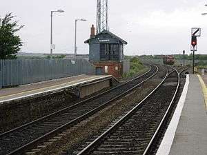 View north from Platform 1 depicting the brake house on Platform 2. | |||||||||||
| Location |
Station Road, Skerries, County Dublin, K34 CF63 Republic of Ireland | ||||||||||
| Coordinates | 53°34′26″N 6°07′08″W / 53.574°N 6.119°WCoordinates: 53°34′26″N 6°07′08″W / 53.574°N 6.119°W | ||||||||||
| Owned by | Iarnród Éireann | ||||||||||
| Operated by | Iarnród Éireann | ||||||||||
| Platforms | 2 | ||||||||||
| Construction | |||||||||||
| Structure type | At-grade | ||||||||||
| Other information | |||||||||||
| Station code | SKRES | ||||||||||
| Fare zone | Suburban 4 | ||||||||||
| History | |||||||||||
| Opened | 1844 | ||||||||||
| Services | |||||||||||
| |||||||||||
Northern Commuter |
|---|
Skerries railway station serves Skerries in County Dublin, Ireland.
History
The station opened on 25 May 1844.
Description
The station has two platforms for the lines that run through the station. There is a footbridge connecting the platforms. An underpass was open, but was closed permanently on Wednesday 31 August 2016. Platform 1 runs mostly south, while platform 2 runs mostly north. The middle of the footbridge is 1 mile from the Martello tower on Red Island and 8 km from Rockabill lighthouse
Services
The commuter train is the only train that stops at the station. The fleet class is the IE 29000 DMU. The only other trains that pass the station are the Dublin to Belfast Enterprise train, the Tara Mine zinc ore freight train led by IE 071 class trains, and an out of service transfer intercity train, which use IE 22000 DMU class trains.
See also
References
External links
| Wikimedia Commons has media related to Skerries railway station. |