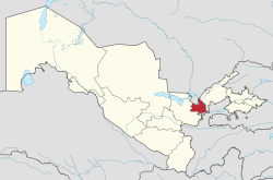
Sirdaryo Region
| Sirdaryo Region Sirdaryo viloyati | |
|---|---|
| region | |
 Sirdaryo in Uzbekistan | |
| Coordinates: 40°25′N 68°40′E / 40.417°N 68.667°ECoordinates: 40°25′N 68°40′E / 40.417°N 68.667°E | |
| Country | Uzbekistan |
| Capital | Guliston |
| Government | |
| • Hokim | Ashurov Oybek Shodmonqulovich |
| Area | |
| • Total | 4,276 km2 (1,651 sq mi) |
| Elevation | 267 m (876 ft) |
| Population (2017) | |
| • Total | 803,100 |
| • Density | 190/km2 (490/sq mi) |
| Time zone | UTC+5 (East) |
| • Summer (DST) | UTC+5 (not observed) |
| ISO 3166 code | UZ-SI |
| Districts | 9 |
| Cities | 5 |
| Townships | 6 |
| Villages | 75 |
| Website |
sirdaryo |
Sirdarya Region (Uzbek: Sirdaryo viloyati, Сирдарё вилояти) is one of the regions of Uzbekistan, located in the center of the country on the left bank of Syr Darya River. It borders with Kazakhstan, Tajikistan, Tashkent Region, and Jizzakh Region. It covers an area of 4,276 square kilometres (1,651 sq mi),[1] and is mostly desert, with the Starving Steppe taking up a significant part of the region's area. The population is estimated to be around 803,100.
Administration
Syrdaryo Region is divided into 9 administrative districts. The capital is the city of Guliston (pop. est. 54,000 inhabitants). Other cities and towns include Baxt, Boyovut, Farhod, Qahramon, Sayhun, Sirdaryo, Khavast, Shirin and Yangiyer.
Demography
The population of the region is distributed along the main highway, which divides the whole region into two parts: the western and the eastern. The population in mainly Uzbek, with Tajik minorities on the border in the south with Tajikistan (mainly Khavast district).
Districts
Climate
The climate is a typically arid continental climate with extreme differences between winter and summer temperatures.
Economy
The economy is based on cotton and cereal crops, with strong reliance on irrigation and on cattle breeding. Minor crops include forage plants, vegetables, melons, gourds, potatoes, maize, a variety of fruit and grapes. Industry consists of construction materials, irrigation equipment and raw-cotton processing.
Syrdarya contains one of Uzbekistan's largest hydroelectric power plants, which generates one third of the country's electricity.
References
- ↑ "Passport of the Syrdarya region". Officiel website of Sirdaryo Region. Retrieved 30 April 2018.
Places adjacent to Sirdaryo Region | ||||||||||
|---|---|---|---|---|---|---|---|---|---|---|
| ||||||||||
Capital: Guliston | ||
| Districts and seats | 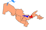 | |
| Other towns | ||
| ||